Virginia, often pictured as a gentle landscape of rolling hills and historic towns, harbors a geographical wildness that defies its placid reputation. Beneath its surface, ancient forces have sculpted a world of hidden wonders, from caverns so vast they host the largest musical instrument on Earth to the buried scars of cosmic impacts. Its mountains cradle ecosystems that time forgot, while its coastlines are in a constant, dramatic flux. This isn't just history, it is a living, breathing landscape where the planet's deep past regularly asserts itself, revealing a topography far stranger and more dynamic than any textbook might suggest.
Subterranean Secrets and Living Caves
World's largest musical instrument lives deep underground.
Beneath Luray Caverns lies the Great Stalacpipe Organ, the world's largest musical instrument, spanning 3.5 acres of solid rock. In the 1950s, a mathematician spent three years tuning 3,700-year-old stalactites to concert pitch. When a key is pressed, rubber mallets strike stones hundreds of feet away, using the entire cavern as a natural sounding board.
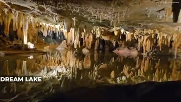
A mirror-like lake is only eighteen inches deep.
Inside Luray Caverns, Dream Lake creates a convincing optical illusion. It appears to be a bottomless abyss, but is in fact only 18 inches deep. The complete lack of airflow creates a surface so still that the ceiling's reflection perfectly masks the true floor. Nearby, the Wishing Well, despite looking shallow, hides a 6-foot drop beneath its coin-laden surface.
Virginia holds thousands of caves and hundreds of miles of passages.
Beneath Virginia's surface lies a hidden world of outrageous proportions, with over 4,000 known caverns containing nearly 600 miles of surveyed passage. This subterranean maze is home to 160 rare species, including blind, pigmentless creatures called troglobites, which evolved in total darkness. Thomas Jefferson himself published the first ever American cave map back in 1787.
The deepest cave east of the Mississippi is in Virginia.
In Wise County, the Omega Cave System plunges 1,263 feet, deep enough to swallow the Empire State Building with 13 feet to spare. Spanning nearly 30 miles, it is also Virginia's longest cave, featuring a continuous underground river that runs for 5.9 miles without ever seeing daylight. Full expeditions here require week-long underground camping trips.
One Virginia cave actually breathes.
In the heart of Virginia's Burnsville Cove, a cave appears to have a pulse. Breathing Cave earned its name because as atmospheric pressure shifts, the cave physically inhales and exhales air through its mouth. Connected to a massive 75-mile network of passages, the cave holds an enormous volume of air, making the ground under Virginia a living, pressurized lung.
Endless Caverns lives up to its name.
Discovered in 1879 by two boys chasing a rabbit, Endless Caverns still lives up to its name 146 years later. Explorers have mapped over 6 miles of winding tunnels and have never found a back wall, with every expedition revealing more unexplored darkness. The site offers Virginia's longest commercial tour, a 75-minute trek that covers only 15 percent of the known labyrinth.
East Coast's deepest commercial cave is found here.
Natural Bridge Caverns goes down 347 feet underground, the deepest commercial cave on the entire US East Coast. Discovered in 1889 right next to the Natural Bridge, it is home to unique creatures like the Natural Bridge Cave Beetle and Isopod, found nowhere else on the planet. You are 34 floors down, standing next to species that have no idea the outside world exists.
Cosmic Scars and Coastal Shifts
A massive asteroid crater hides under the bay.
Thirty-five million years ago, a space rock three miles wide slammed into Virginia at 40,000 miles per hour, carving out a crater 53 miles wide and nearly a mile deep. This, the biggest impact site in America, was unknown until the 1990s when drillers hit strange salty water and shocked rocks. The impact was so violent it sent a tsunami crashing all the way to the Blue Ridge Mountains.
The impact scattered molten glass across millions of square miles.
The Chesapeake impact basically turned the sky into a furnace. Vaporized rock shot 30 miles high, creating a mushroom cloud that rained molten glass beads, called tectites, across the eastern seaboard. This debris spread over 4 million square miles, from Massachusetts to Barbados. A 500-foot mega tsunami slammed into the land, reaching the Blue Ridge Mountains 450 miles away.
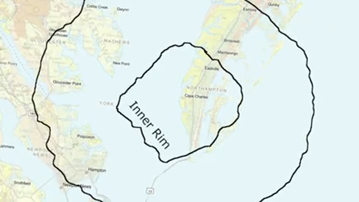
Ancient asteroid still makes tap water salty.
That asteroid from 35 million years ago is still causing problems. When it hit, it shattered underground aquifers and trapped a massive pocket of ancient seawater up to 145 million years old. This brine is twice as salty as the modern ocean and completely undrinkable. The crater's rim acts like a giant invisible wall, with fresh water just feet outside the 50-mile circle.
The buried crater still controls river flow.
This buried beast does not just mess with groundwater, it has been rerouting rivers for millions of years. The York and James rivers both make sharp, unnatural turns exactly where they cross the crater's outer rim. This ancient scar essentially predetermined the location of the modern Chesapeake Bay, and the crater's rubble zone is still settling, causing the Hampton Roads area to sink up to 23 centimeters per century.
The asteroid's gone, but it's still reshaping Virginia from below.
Chesapeake Bay has more shoreline than the entire US West Coast.
The Chesapeake Bay holds 11,684 miles of shoreline, more than the entire US West Coast combined. One estuary with a coastline more complex than California, Oregon, and Washington's Pacific seaboard put together. Despite its massive footprint, the bay is shockingly shallow, averaging just 21 feet deep. Nearly a quarter of it is less than six feet.
The Chesapeake Bay is a geologically young, drowned river.
The Chesapeake Bay is a geological newcomer, having not even existed 12,000 years ago. Before the glaciers melted, the Susquehanna River ran hundreds of miles further, cutting a deep valley to the Atlantic shelf. When sea levels rose 400 feet, the ocean flooded that valley and never left. Sea levels here are rising twice as fast as the global average.
Virginia is losing its islands to rising waters.
Virginia is losing its islands, with over 400 islands in the Chesapeake Bay completely disappearing since the 1600s. Sharps Island, once home to a three-story hotel and 450 acres, is now open water. Tangier Island, the most famous survivor, has lost 67 percent of its land since 1850, with experts predicting total evacuation by 2050.
Untamed Waters and Ancient Swamps
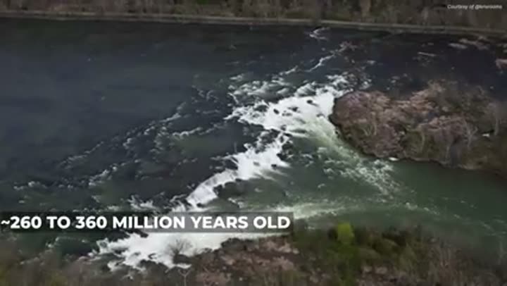
The New River is older than the mountains it flows through.
Despite its name, the New River is one of the five oldest rivers on the planet, estimated at 260 to 360 million years old. It actually predates the Appalachian Mountains. As the range slowly rose 300 million years ago, the river eroded the bedrock at the same pace, literally sawing through the growing mountains for eons. It also flows south to north, against the grain of the continent.
Saltwater fish migrate to downtown Richmond.
In Richmond, water levels fluctuate up to two feet every six hours, allowing blue crabs and 14-foot Atlantic sturgeon to migrate all the way upriver to the city's fall line. This series of rapids blocked colonial ships and forced Richmond's founding as a port. The result is a surreal scene, with ancient saltwater giants spawning within sight of the state capital building.
Dragon Run is called the "Amazon of Virginia."
Deep in the Middle Peninsula, Dragon Run is a 40-mile blackwater stream winding through ancient cypress swamps where time feels like it stopped. The water is stained tea-dark by tannins, flowing past trees older than the Revolutionary War. This 140 square mile wilderness is so remote it contains only 500 houses, earning it a Smithsonian ranking as the Chesapeake's second most vital ecological site.
The Great Dismal Swamp was once larger than Rhode Island.
The Great Dismal Swamp used to be over a million acres, a wilderness so huge that George Washington personally led a failed effort to drain it in 1763. Today, only 10 percent remains, anchored by the mysterious Lake Drummond. This 3,100-acre perfectly circular lake sits 18 feet above sea level, yet it is only six feet deep and fed by no visible rivers or streams.
Swamp water was once prized as liquid gold.
The dark, tea-colored water of the Great Dismal Swamp was once the most prized supply on the eastern seaboard. It looks murky and uninviting, but the water is saturated with tannic acid from cypress and juniper trees. That natural acidity kills bacteria so effectively the water stays fresh for months without refrigeration. Legend says Blackbeard's crew resupplied here to stay hydrated on long Atlantic crossings.
The Great Dismal Swamp can burn for months.
Virginia's most famous swamp is literally a powder keg. The soil is made of peat, thick, decaying plant matter that stores more carbon than almost any other soil type on Earth. When it dries out, it gets crazy flammable. In 2011, a lightning strike ignited a zombie fire that burned underground for 111 days, with smoke plumes visible from space and choking the air 100 miles away in Richmond.
World's tallest bald cypress tree grows in Virginia.
Near Williamsburg, a 145-foot bald cypress stands, officially the tallest known specimen of its species on the planet. The ancient swamps along the Blackwater River are full of 800-year-old giants with 12-foot diameters. The land looks like it was transplanted directly from a Louisiana bayou, but these forests have been a fixture of Virginia for centuries.
Mountain Wonders and Geological Giants
Carnivorous plants thrive in mountain bogs.
High in the Allegheny Mountains, Virginia hides an ecological time capsule from the last ice age. At elevations above 3,000 feet, rare mountain bogs form spongy, acidic peatlands that have no business existing this far south. These relict ecosystems host species typically found in Canada, including wild cranberries, rare orchids, and carnivorous predators like sundews and pitcher plants.
Dirty Dancing's iconic lake periodically disappears.
Virginia is home to Mountain Lake, the iconic filming location for Dirty Dancing, which disappears every now and then. Sitting at 3,875 feet, its floor is riddled with natural piping holes that act like bathtub drains. In 2008, the lake almost emptied completely, leaving its famous gazebo stranded in a dry field. This self-cleaning cycle has happened at least six times in 6,000 years.
America's oldest spa structure is found here.
Bath County is home to the oldest spa structure in America, the octagonal Gentleman's Pool House, standing since 1761. Paleoindigenous peoples used these thermal waters over 9,000 years ago. The springs at the Omni Homestead Resort still hit a steamy 106 degrees Fahrenheit. Even Thomas Jefferson spent three weeks here in 1818, praising the water but complaining about the intense boredom.
Active freight trains run through a natural cave.
In Scott County, the Natural Tunnel is an 850-foot long limestone cave that doubles as an active freight railway. It towers 10 stories high and was once called the Eighth Wonder of the World. Unlike tunnels blasted out by engineers, this one was carved by a river over a million years. Since 1894, coal trains have thundered through its fossil-filled walls.
Thomas Jefferson bought a natural arch for pocket change.
In 1774, Thomas Jefferson paid King George III just 20 shillings, roughly $2.40, for the Natural Bridge in Rockbridge County. Jefferson called it the "most sublime of nature's works." It is taller than Niagara Falls and contains 36,000 tons of limestone. US Route 11 runs across the top of the arch, meaning thousands of drivers cross it every day without realizing they are 20 stories above the canyon floor.
Limestone towers resemble medieval castles.
In the Shenandoah Valley, seven limestone towers emerge from the earth like the ruins of a medieval fortress. Known as the Natural Chimneys, these 120-foot spires are 500-million-year-old remnants of an ancient inland sea, with dark volcanic lava sandwiched inside the stone. Since 1821, this site has hosted an annual jousting tournament, America's oldest continuous sporting event.
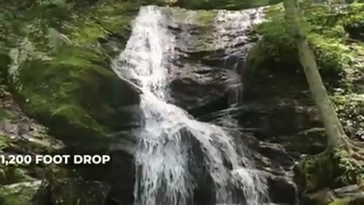
East's tallest cascading waterfall is dangerously beautiful.
Virginia is home to Crabtree Falls, the tallest cascading waterfall east of the Mississippi, and it holds a grim record. It plunges 1,200 feet across five massive drops, nearly twice the height of the Washington Monument. Its beauty masks a deadly threat, as see-through algae coats the rocks, making them slick as ice. Since 1982, at least 30 people have fallen to their deaths here.
A 48-million-year-old volcano hides in plain sight.
Just minutes from downtown Harrisonburg, a 48-million-year-old volcano hides in plain sight. Mole Hill looks like a typical ridge, but it is actually a volcanic plug, the frozen core of an ancient cinder cone. While the surrounding valley formed 500 million years ago, this basalt peak is a geological infant by comparison. It once blasted through limestone at 1,400 degrees Celsius.
Virginia's youngest volcano is grazed by sheep.
Virginia's youngest volcano is a quiet sheep pasture. Trimble Knob in Highland County is a 3,100-foot volcanic plug that went silent about 35 million years ago. When it was active, magma blew toward the surface at almost 70 miles per hour, completing the journey from the Earth's mantle in less than four days. Today, it is just a grassy hill where sheep graze in peace.
A 2011 earthquake shook one-third of the US.
On August 23, 2011, a 5.8 magnitude earthquake near Mineral, Virginia, became the first seismic event to go viral. Seismic waves travel slower than internet signals, so people in New York were reading about the quake on Twitter roughly 30 seconds before they felt it. It was felt by 100 million people, one-third of the entire US population, cracking the National Cathedral and triggering the first ever automatic shutdown of a US nuclear plant.
Deep Time and Lost Worlds
Virginia was once attached to Africa.
About 250 million years ago, when the supercontinent Pangea came together, Virginia sat right in the middle of it, firmly welded to what is now northwest Africa. The collision between the two plates shoved the Appalachians up to possibly 25,000 feet, rivaling the modern Himalayas. Before that, Virginia sat near the equator under a humid tropical climate.
Blue Ridge rocks are over a billion years old.
The rock under your feet in the Blue Ridge is almost unbelievably old. The Rockies are 80 million years old, the Himalayas are 50 million, but Virginia's Blue Ridge bedrock is over 1.1 billion years old. These stones formed deep in the Earth's crust during the supercontinent Rodinia, way before dinosaurs or complex life of any kind existed. Today's mountains are the weathered remnants of a billion years of planetary history.
Virginia was repeatedly covered by ocean waters.
Virginia was not always dry land. Just three million years ago, the Atlantic Ocean stretched 50 miles further inland, covering the entire coastal plain, including Norfolk and Virginia Beach, under 60 feet of water. Downtown Richmond was beachfront property. This ancient ocean left behind the Yorktown Formation, a thick fossil layer where crews still pull shark teeth and whale bones miles inland.
The most beautiful waterfall in the east is also its most dangerous.
Megalodon teeth found on river beaches.
In Virginia, you can spend your weekend hunting the teeth of prehistoric monsters. At Westmoreland State Park's Horsehead Cliffs, erosion drops millions of years of history onto the beach below. Visitors find fossilized teeth from tiger sharks, makos, and the legendary Megalodon, a bus-sized predator that ruled these waters 10 million years ago. The beach is basically a museum with no admission fee.
Thousands of dinosaur footprints, but no bones.
Not a single dinosaur bone has ever been found in Virginia. But a quarry in Culpeper holds something almost better: over 4,800 footprints etched into 210-million-year-old stone. These trackways reveal a prehistoric highway where carnivorous theropods, some reaching 13 feet long, sprinted at 20 miles per hour. Virginia's acidic soil likely dissolved the skeletons ages ago, but the stone preserved their precise movements.
Unconventional Borders and Epic Trails
Virginia once stretched to the Pacific Ocean.
Virginia used to be a transcontinental empire. Under its 1609 royal charter from King James I, the colony officially stretched from the Atlantic to the Pacific, technically claiming everything in between, including modern-day Chicago and California. Over the next 250 years, the state went on a massive diet, ultimately shrinking to just 9 percent of its original chartered size.
Two counties are physically cut off from the state.
Accomack and Northampton County sit on the Delmarva Peninsula, completely separated from mainland Virginia by the Chesapeake Bay. Until the 17.6-mile Chesapeake Bay Bridge-Tunnel opened in 1964, the Eastern Shore was essentially unreachable from the rest of the state by land. The peninsula is so geographically detached that the state senate once accidentally left it off a graphic of Virginia.
A state line runs down the middle of a street.
In Bristol, the border between Virginia and Tennessee runs directly down the center of State Street. Brass markers embedded in the asphalt act as a geographic spine, separating two states. You can literally stand with one foot in each. This shared downtown is a single heartbeat for two distinct cities that split everything else, including separate governments and police departments.
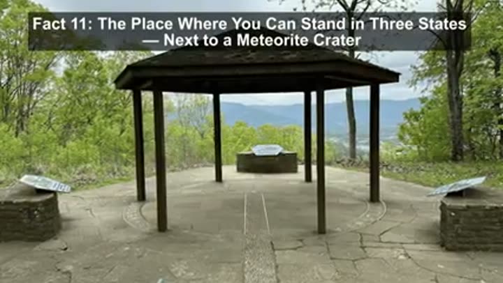
Stand in three states next to a meteorite crater.
At the Cumberland Gap, you can stand in three states at once, right next to a city built inside an asteroid impact crater. At Tri-State Peak, the borders of Virginia, Kentucky, and Tennessee come together 2,000 feet above the famous Gateway to the West. The true wonder is just next door: Middlesboro, Kentucky, sits entirely within a 3.7-mile wide impact crater formed 300 million years ago.
One quarter of the Appalachian Trail is in Virginia.
The Appalachian Trail runs through 14 states, but Virginia practically claims it as its own. The Commonwealth holds 550 miles of the path, one quarter of the entire trail packed into a single state. It is so long that thru-hikers spend a full month here, often hitting a psychological wall known as the "Virginia Blues" before reaching the end of its ancient terrain.
Highland Havens and Ecological Enigmas
Virginia's highest peak offers no view.
Virginia's highest peak is a total geographic troll. Mount Rogers stands at 5,729 feet, but if you are expecting a clean view at the summit, forget it. The top is completely buried in forests so thick it feels like the Pacific Northwest. Its rocks prove that 760 million years ago, this spot was a raging volcano, and later, the only place in Virginia touched by an ancient ice sheet.
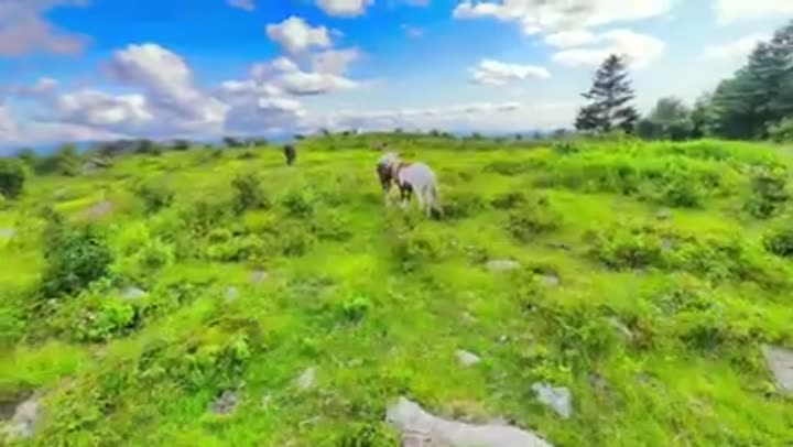
Wild ponies graze at five thousand feet.
At 5,000 feet in the Grayson Highlands, Virginia has a workforce of about 150 feral ponies that have been on the job since 1974. They were originally brought to these mountain peaks as four-legged lawnmowers, eating back the brush to keep the balds from turning into forest. These rugged survivors endure brutal winters and high-altitude winds year after year.
An entire plant species lives on one mountain.
Virginia is home to the ultimate botanical last stand: the Peters Mountain Mallow, which exists on exactly one mountain ridge in Giles County and nowhere else on Earth. By 1992, the global population had dipped to just three plants. Their seeds are so heavily armored they need the intense heat of a wildfire to germinate, and after experts began prescribed burns, the population clawed back to around 50 plants.
Virginia's very own lungless salamander.
Virginia is the only home to a creature that breathes through its skin and lives on just three specific mountain slopes. The Shenandoah salamander is a lungless wonder whose entire global range covers just 800 acres, smaller than a single golf course. These 140,000 survivors are relics of the ice age, pushed into rocky hideouts by turf wars with more aggressive local salamanders.
Twenty-three uninhabited barrier islands protect the coast.
Stretching 70 miles along Virginia's Eastern Shore, 23 uninhabited barrier islands form the longest undeveloped barrier island chain in the entire temperate zone on Earth. The United Nations designated them an international biosphere reserve. In the 1960s, developers had plans to build bridges and condos, but The Nature Conservancy quietly purchased 14 of the islands before a single shovel hit the ground.
The Human Footprint, Geologically Defined
Virginia once owned the city of Pittsburgh.
One of America's greatest industrial cities almost belonged to Virginia. Before the 1780s, the entire city of Pittsburgh was officially part of Virginia's Yohogania County. Virginia's governor even seized the local fort, renaming it Fort Dunmore to assert dominance. The border dispute with Pennsylvania got so heated that Benjamin Franklin suggested creating an entirely new colony. Virginia eventually ceded the territory to finalize the Mason-Dixon line.
Dismal Swamp Canal is America's oldest artificial waterway.
Hand-dug starting in 1793, the Dismal Swamp Canal took 12 years of backbreaking labor from enslaved workers to complete. George Washington was obsessed with this place. For over 220 years, this 22-mile channel has never stopped operating, once serving as a treacherous highway for timber and a secret sanctuary for maroon communities escaping slavery. Today, you can still boat through its tea-colored waters.
Virginia experiences extremely wide temperature swings.
Most people think of Virginia as mild and moderate, but the thermometer tells a different story. The state's all-time high is a blistering 110 degrees Fahrenheit, while its all-time low is 30 degrees below zero. That is a 140-degree swing. To put that in perspective, the gap between a comfortable room and a pot of boiling water is only 142 degrees. Virginia has recorded temperatures that would be right at home in the Mojave Desert and the Alaskan interior.
The Fall Line dictated where major cities were built.
Virginia's major cities were not founded by coincidence, they were dictated by a geological boundary most people cannot even see. The Fall Line marks where hard Piedmont rock meets soft coastal plain sediment, creating an invisible staircase where rivers drop roughly 100 feet in elevation. Alexandria, Fredericksburg, Richmond, and Petersburg all sit precisely on this line because it was the furthest inland that ships could travel before hitting impassable rapids.
So there you have it, 50 glimpses into a Virginia that constantly reminds us of geography's profound influence. From the cosmic violence that shaped its bays to the slow, relentless carving of its rivers, the Old Dominion is a testament to the Earth's enduring power. It is a place where the ground beneath your feet holds stories of ancient collisions, where the air itself breathes from hidden networks, and where every turn reveals another plot twist in the planet's grand narrative. The world, indeed, is far stranger and more fascinating than school ever taught.


