The boundary between the United States and Canada stretches for an astonishing 5,525 miles, making it the longest international border on Earth. Yet, this isn't some predictable line drawn with modern precision. It's a geographical marvel, a testament to antique surveying blunders, political compromises, and the sheer force of nature. From towns split down the middle to lakes that are technically one, this border is less a neat division and more a series of fascinating, often absurd, plot twists etched across the continent. Prepare to have your understanding of international lines completely redrawn.
The Invisible Line, Visible Chaos
The world's longest clear-cut strip is the border itself.
Running the entire length of the US Canada border is a 20 foot wide corridor where every single tree has been deliberately cut down and kept clear. This "border vista" is maintained around the clock by the International Boundary Commission, even through hundreds of miles of remote Alaskan and Yukon wilderness. From space, it appears as a razor-thin line slicing across the continent, ensuring everyone knows precisely where the boundary lies.
The "straight line" border is actually 900 crooked segments.
On maps, the border from Minnesota to the Pacific Ocean appears as a perfectly straight cut along the 49th parallel. In reality, 19th century surveyors, using only compasses, stars, and chains, created over 900 segments that wander up to 810 meters off the true parallel. A 1908 treaty officially declared these physical markers, however misplaced, to be the real border, turning a theoretical line into a stumbling, zig-zagging reality.
Canada gained 26 square miles from surveying errors.
The southward drift of those early 19th century surveyors along the 49th parallel resulted in a significant accidental land transfer. Canada inadvertently acquired roughly 26 extra square miles of territory that mathematically should belong to the United States. This area is three square miles larger than Manhattan, a chunk of land the US technically lost due to outdated technology that struggled to track a perfect curve across a continent.
The eastern border is just as crooked as the western one.
The surveying blunders weren't limited to the west. The border from New York through Vermont to New Hampshire, intended to follow the 45th parallel, also exhibits significant deviations. Surveyed in the 1770s with imprecise instruments, the line wanders more than a mile off the correct parallel in some stretches. Today, over 420 monuments lock this surveyed line in place, making the wrong answer the permanent and official answer.
Eight thousand monuments outlasted every dispute.
Across 5,525 miles of varied terrain, over 8,000 individual monuments mark the US Canada border. These range from 1800s granite obelisks to small metal cones and concrete pillars in back gardens. They have survived blizzards, floods, and countless diplomatic arguments, standing as physical reminders of a border that, despite its quirks and errors, has remained largely peaceful and undisputed for centuries.
The physical markers, no matter how misplaced, became the real border. So that straight line, it stumbles like it's had one too many.
Enclaves and Exclaves: Towns That Defy the Map
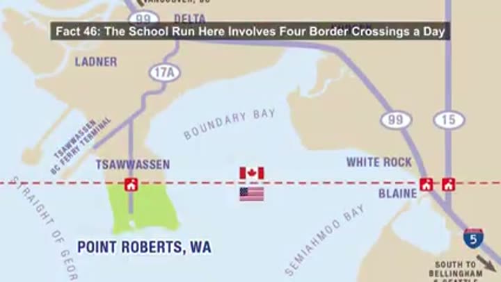
Point Roberts: a US town reachable only through Canada.
Point Roberts, a five square mile accident of geography, was created when the 49th parallel sliced through a Canadian peninsula, stranding a piece of Washington state. Its 1,200 full-time residents must cross into British Columbia for most services, including groceries and doctors. During the 2020 border closure, the town became a ghost town, with 85% of its income from Canadian shoppers vanishing, necessitating an emergency ferry service.
School run involves four border crossings a day.
Children living in Point Roberts face one of the world's most complicated school commutes. After third grade, they board a bus that drives into Canada, re-enters Washington State at Blaine, and reverses the route every afternoon. This means four international border crossings daily, with passports required for math class. The pandemic forced families to choose between moving, splitting up, or removing their children from school.
America's northernmost point is an exclave.
The Northwest Angle, a 123 square mile chunk of Minnesota, is the only part of the contiguous US north of the 49th parallel. Its existence is due to a mapmaker's error in the 1783 Treaty of Paris, which incorrectly mapped Lake of the Woods. This exclave has no land connection to the rest of the country, forcing its residents to cross into Canada for basic necessities like groceries.
Entering Minnesota from Minnesota requires leaving the country.
To reach the Northwest Angle by car from the rest of Minnesota, one must drive north to Warroad, cross into Canada, traverse over 60 miles of Manitoba gravel roads, then re-enter the US at the Angle, clearing customs twice. Other options include boating across Lake of the Woods in summer or snowmobiling in winter, making it the most isolated piece of lower 48 territory.
US Customs at the Angle is a phone booth.
Border security at America's most geographically awkward outpost is surprisingly minimal: a gravel parking lot called Jim's Corner featuring a small booth with a video phone. Travelers press a button, a customs officer appears on screen, asks questions, and cameras verify the vehicle. This entire apparatus, roughly the size of a phone box, protects the northernmost point of the contiguous United States, and it works perfectly well, if humorously.
Angle residents once threatened to join Canada.
In 1997, the roughly 100 residents of the Northwest Angle staged a unique protest. When Ontario banned Americans from keeping fish unless they stayed at Canadian resorts, threatening the Angle's livelihood, residents threatened to defect to Manitoba. This publicity stunt involved a proposed constitutional amendment and forced the US government to intervene, leading to harmonized fishing rules and ensuring the Angle remained American.
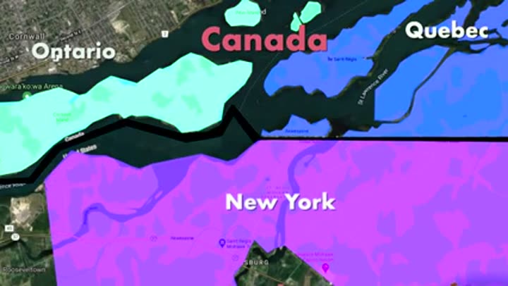
A Native American nation is split by three governments.
The Mohawk territory of Akwesasne existed long before the border, which now slices it across New York, Ontario, and Quebec. This creates an administrative maze where three separate governments manage the community. Due to the St. Lawrence River, the Quebec side is an exclave, requiring residents to drive through New York and clear US customs just to reach the rest of Canada. The border is so invasive it even cuts through individual houses.
One street has the international border as its center line.
On Canusa Street, between Beebe Plain, Vermont, and Stanstead, Quebec, the yellow center line is not just a lane divider; it's an international border. The north side is Canada, the south side is America. Local legend claims surveyors drew the 45th parallel directly through people's front yards. Crossing the street for a cup of sugar technically constitutes illegal entry, leading residents to use flower pot fences to prevent accidental crossings.
Derby Line has houses with two nationalities.
Beyond the famous Haskell Library, at least five other buildings in Derby Line, Vermont, sit in two countries at once. One home has its kitchen in the US and its dining room in Canada. Another was a tool factory where the border sliced directly through the machinery. To remain legal, residents must use specific doors; exiting the wrong way technically counts as an illegal border crossing, making walking the line a literal daily activity.
Lake Metigoshe's backyard border divides property.
In a unique geographic glitch at Lake Metigoshe, the border slices directly through people's backyards, impacting several Canadian families who own cottages there. Their living rooms might be in Manitoba, but their boat docks sit in North Dakota. Every time they walk to the water for a swim, they technically enter the United States. Some even pay property taxes to both countries to maintain their homes and docks.
Nature's Grand Divide: Water, Ice, and Rock
Great Lakes hold 21 percent of world's surface freshwater.
Four of the five Great Lakes, Superior, Huron, Erie, and Ontario, form a massive liquid boundary between the US and Canada. Only Lake Michigan is entirely American. Together, these inland seas hold over 20 percent of the planet's surface freshwater. If this water were poured over the entire lower 48 states, the country would be submerged under nearly five feet of water, highlighting their immense scale and shared ecological importance.
Lake Michigan and Lake Huron are technically one lake.
While commonly considered two distinct bodies, Lake Michigan and Lake Huron are hydrologically one continuous lake, connected by the five-mile wide Straits of Mackinac. The straits ensure their water levels are identical and exchange enough volume daily to fill the Mississippi River. If maps reflected this scientific reality, the combined Lake Michigan Huron would be the largest freshwater lake on Earth by surface area, surpassing Lake Superior.
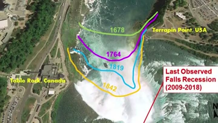
Niagara Falls is slowly walking backward.
Niagara Falls is retreating upstream, a process that has been ongoing since its formation 12,500 years ago. It originally sat seven miles downstream near Lewiston, New York. The water's force erodes soft shale beneath hard limestone, causing the cliff face to collapse. In the 1800s, it retreated five feet per year. Diversion for hydroelectric power has slowed this to about one foot annually, but in roughly 50,000 years, the falls will reach Lake Erie and flatten into rapids.
US Army once turned off Niagara Falls.
In June 1969, the US Army Corps of Engineers achieved the seemingly impossible: they turned off the American side of Niagara Falls. They constructed a 600-foot dam using 28,000 tons of rock, diverting the entire river to the Canadian side. This exposed the American cliff for the first time in 12,000 years, revealing jagged boulders, millions of coins, and two sets of human remains. After months of stabilization work, the dam was blown, and the falls roared back to life.
Up to 75 percent of Niagara's water is secretly diverted.
What tourism brochures often omit is that up to 75 percent of the Niagara River's water is routinely diverted into hydroelectric tunnels before reaching the falls. This primarily occurs overnight and during winter when visitor numbers are low. During peak daytime hours, a US Canada treaty mandates a minimum flow to maintain the impressive spectacle. Outside these windows, much of the river disappears underground to generate electricity.
Niagara Falls dissolves 60 tons of rock per minute.
The iconic glowing green color of Niagara Falls is not a filter, but a visual representation of Earth being pulverized. Every minute, the river carries away roughly 60 tons of dissolved minerals and rock flour, primarily calcium carbonate from the limestone riverbed. This fine powder remains suspended, reflecting sunlight into its signature emerald hue. At the base, a process called cavitation, where air bubbles collapse with immense force, further shatters the rock.
Ice volcanoes form on the Great Lakes.
In the frigid depths of winter, the Great Lakes shoreline witnesses a rare phenomenon: ice volcanoes. These form when powerful winter waves become trapped under the ice shelf. The immense pressure forces water up through cracks, spewing it into the freezing air where it solidifies almost instantly. These icy cones can reach heights of 30 feet, acting as natural barriers against storms, though their hollow craters pose a significant danger to anyone who ventures too close.
Massive salt deposits hide under border lakes.
Long before the Great Lakes existed, this entire region was covered by shallow inland seas. These ancient seas evaporated, leaving behind enormous salt deposits buried thousands of feet below what are now Lake Erie and Lake Huron. Today, these deposits are actively mined through underground operations that have been running since the 1950s. The salt primarily serves to de-ice winter roads across the Northeast, revealing a hidden world beneath the international boundary.
The Great Lakes are geological infants.
Despite their grandeur, the Great Lakes are surprisingly young. Just 14,000 years ago, the entire region was buried under two miles of ice. As this ice melted, it carved out the basins we see today. Humans were already domesticating wheat in the Middle East before these lakes even formed. The Great Lakes didn't settle into their current shapes until about 3,000 years ago, making them younger than the pyramids of Egypt.
Ground near the border is still rising.
The land along the US Canada border is physically moving upward due to a process called isostatic rebound. During the last ice age, miles-thick glaciers pressed the Earth's crust down by hundreds of feet. With the ice gone, the land is slowly bouncing back. This uplift is significant enough that GPS stations along the border require recalibration annually. In Lake Huron, the rising crust is even pushing new islands out of the water and stranding historic boat docks hundreds of feet from shore.
Niagara Falls rocks are fossilized tropical reefs.
Niagara Falls, a symbol of the frigid north, is actually built from ancient equatorial material. Four hundred forty million years ago, this border region sat under a warm, shallow tropical sea. The caprock that holds the falls together is a fossilized reef, composed of billions of ancient marine creatures, known as Lockport Dolostone. This formation acts as a stone shelf, resisting the water's erosion while the softer shale beneath it crumbles away.
Lake Superior is so big it creates its own weather.
Lake Superior, the largest freshwater lake on Earth by surface area, profoundly influences the border region's climate. Its immense thermal mass buffers temperatures, cooling summers and softening winters. When cold air masses cross it, Superior generates powerful lake effect snowstorms, capable of dumping feet of snow on the shoreline in hours. It also produces waves topping 20 feet in severe storms, having claimed hundreds of ships over the centuries.
The border runs through Earth's oldest exposed rock.
The Canadian Shield, the ancient Precambrian bedrock underlying much of Ontario and Minnesota, represents one of the oldest exposed geological surfaces on the planet. Sections of this rock are over four billion years old, predating the existence of fish, complex life, and even sufficient atmospheric oxygen for animals to breathe. Glaciers scraped away overlying material, exposing the raw, primordial basement of the North American continent, directly through which the border runs.
That thundering cascade you're snagging pictures of is absolutely real, but it's also a tightly managed production running on a schedule.
Wilderness Boundaries: Where Nature Swallows the Line
The border runs through over 1,800 islands.
The Thousand Islands stretch of the St. Lawrence River more than lives up to its name. Here, the US Canada border threads its way through over 1,800 individual islands. Some are large enough for opulent mansions, while others are barely big enough to hold a single flagpole. Some islands are entirely American, some entirely Canadian, and some famously straddle the line, with neighbors close enough to row between in minutes.
The border disappears into a vast canoe wilderness.
Where Minnesota's Boundary Waters meet Ontario's Quetico Provincial Park, the US Canada border vanishes into 2.2 million acres of protected wilderness. For 150 miles, the boundary zigzags through over a thousand glacial lakes. There are no customs booths or paved roads, only brass markers on ancient granite and a 20-foot clearing through the pine forest. To cross here, one simply paddles across an invisible line, letting nature swallow the border whole.
Accidental canoe crossings are common in the wilderness.
In the Boundary Waters, it's easy to become an international trespasser without even trying. The forest looks identical on both sides, there's no cell service, and no signs. Hundreds of canoeists unknowingly drift into Canada or the US annually. Technically, a remote area permit is required to cross. While paddling along border lakes without paperwork is common, if one's boots touch the wrong shore, it constitutes an illegal entry, making it perhaps the gentlest international incident one can commit.
Border markers are transported by canoe in the wilderness.
While most of the US Canada border is maintained with high-tech sensors, in Minnesota's Boundary Waters, it's maintained with a paddle. This protected wilderness bans motors, forcing the International Boundary Commission to use canoes. Crews portage deep into the forest to repair border monuments by hand, following the same trails indigenous nations and fur traders used centuries ago. Markers are built in segments and carried for miles over rock and mud, a 21st century boundary maintained with 17th century muscle.
The border follows a highway that predates it by millennia.
The US Canada border between Lake Superior and Lake of the Woods follows ancient paths. This region, encompassing the Pigeon River, the Boundary Waters Chain, and old portage trails, served as the main travel corridors for indigenous peoples for thousands of years, and later for French Canadian voyagers in the fur trade. Diplomats didn't invent a border here; they simply traced one that already existed, a highway written in water millennia before anyone put it on a map.
Shared Spaces, Divided Lives: Unique Border Crossings
Six airports straddle the border with runways in both countries.
There are six airports along the US Canada border where aircraft can land in one country and taxi into the other without leaving the pavement. Runways like Piny Pine Creek in Minnesota physically straddle the line. At Avey Field in Washington, planes can land in the US but must be officially exported just to refuel, as the gas pumps are in British Columbia. These aren't loopholes; they are heavily monitored, and while rolling across is permitted, stepping onto the wrong side without customs clearance is not.
Two border crossings are one way only.
Among the 119 official crossings, two operate like revolving doors that only spin in one direction. At Trout River, New York, one can enter the US from Canada, but heading north is prohibited. Similarly, at Four Falls, New Brunswick, entry into Canada from Maine is allowed, but the reverse is not. This is a hard rule of international sovereignty, with no workarounds or U-turns; it is the only place on the continent where the border is a literal one-way street.
A library allows entry in America and reading in Canada.
The Haskell Free Library, built in 1904 directly on the Vermont Quebec border, is a unique institution. A black line across the floor marks the international boundary. For over a century, visitors could step across this line inside the building without a passport, sharing books and conversation. However, changes in 2025 mandated that US authorities now require Canadians to clear border control before entering through the American side, leading to an old emergency exit serving as a separate Canadian entrance.
Watch a show in America performed on a Canadian stage.
Directly above the Haskell Library is a 400-seat Victorian opera house with an extraordinary layout. The audience sits in the United States, while the actors perform in Canada. The 1783 border cuts diagonally through the building, marked by a black line across the floor and under the seats. Front row patrons might have their feet in Quebec while holding popcorn in Vermont. Even the backstage area, where actors change, is fully Canadian, making it the only venue on Earth where an audience watches a live show happening in another country.
A golf course is split between two countries.
At Aroostook Valley Country Club, a bad slice on the golf course can become an international incident. Built in 1929 to circumvent Prohibition, the founders placed the car park in Maine but the bar in Canada. Golfers could drive in America and drink in New Brunswick without leaving the course. Today, security is tighter, requiring a drive to an official checkpoint just to get from the car to the first tee. Retrieving a ball hooked into Canada is now technically an illegal border crossing.
Echoes of Conflict, Seeds of Peace
Fort Blunder: US built a fort in Canada.
In 1816, the US began constructing a massive stone fortress on Lake Champlain to defend against Canadian invasions. One problem: a new survey revealed the border sat a mile further south, meaning America had accidentally built its state-of-the-art defense on British soil. Mortified, the military abandoned what locals dubbed "Fort Blunder." Farmers stripped the stones for barns, and an 1842 treaty eventually bent the border to allow the US to rebuild the site as Fort Montgomery.

The Peace Arch is a poetic border monument.
At the Blaine, Washington crossing, one of the busiest on the entire border, a 67-foot concrete arch straddles the line, with one foot planted in each country. Built in 1921 to commemorate a century of peace, it sits within a small international park accessible to citizens of both nations without a passport. The American side reads, "Children of a common mother," while the Canadian side proclaims, "Brethren dwelling together in unity," marking one of the border's most human moments.
Alaska panhandle betrayal helped birth a nation.
In 1903, Canada felt betrayed over the Alaska panhandle border dispute. A six-person tribunal, with three Americans, two Canadians, and one British judge, was to settle the matter. The British judge sided with the Americans, denying Canada access to vital Pacific Coast inlets for Yukon trade routes. Canadian members refused to sign the ruling, and Prime Minister Laurier used the humiliation to argue for Canada's need for an independent foreign policy, separate from Britain.
Last disputed territory is ruled by puffins.
The final piece of land disputed between the US and Canada is Machias Seal Island, a 20-acre rock in the Atlantic. Both countries have claimed it since the Revolutionary War. Canada stations two lighthouse keepers there annually as human flags of sovereignty, even though the lighthouse is automated. The US claims the island but largely leaves it to its true rulers: nearly 10,000 Atlantic puffins. Visitors from Maine can land without a passport, meet Canadian staff, and let the birds sort out ownership.
Both countries agreed to ignore the Machias Seal dispute.
When the US and Canada brought their Gulf of Maine maritime boundary to the International Court of Justice in 1979, they made a deliberate choice: Machias Seal Island would not be mentioned. Neither country wanted to risk an unfavorable ruling, so they agreed to leave it off the table entirely. The island remains in legal limbo to this day, with fishermen from both nations working the same disputed waters under different regulations, an official strategy of permanent silence.
Prohibition made the border a whiskey superhighway.
When the US enacted Prohibition in 1920, the Canadian border transformed into the continent's largest liquor pipeline. The Windsor-Detroit corridor, a mile-wide stretch of river, handled 75 percent of all illegal alcohol entering America. Rum running became Detroit's second largest industry, trailing only car manufacturing. Smugglers used high-speed boats, underwater cables, and convoys that drove straight across the winter ice. Today, the river bottom is littered with the remains of rumrunner cars that crashed through.
The Pig War was almost started by a farm animal.
In 1859, the US and Great Britain nearly went to war over a single farm animal. On San Juan Island, a disputed rock between Washington State and British Columbia, an American settler shot a pig belonging to a British farmer for eating his potatoes. Within weeks, the US sent 400 soldiers, and Britain responded with five warships and 2,000 men. For 13 years, both armies camped on opposite ends of the island, famously throwing dinner parties and playing cricket instead of fighting. The Kaiser of Germany eventually ruled in America's favor; the pig remained the only casualty.
The Aroostook War was fought over beans and a black bear.
In 1838, the US and Britain almost engaged in a full-scale war over a forest in Maine, known as the Aroostook War or the "Pork and Beans War." Fifty thousand troops were mobilized on both sides, yet not a single battle was fought. The only casualty was a black bear shot by Canadians, which sparked a confused skirmish in the dark. Diplomacy, through the Webster-Ashburton Treaty, prevented bloodshed and even bent the border south enough for the US to reclaim Fort Blunder.
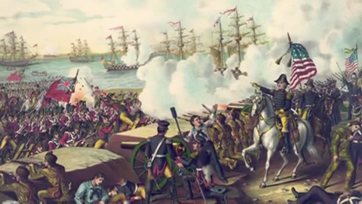
Treaty banning warships on Great Lakes held since 1817.
In 1817, five years after a mutually exhausting war, the US and Britain signed the Rush-Bagot Agreement. This treaty stripped naval forces on the Great Lakes down to a handful of small vessels each, prohibiting warships and arms buildup. It was one of the first formal arms control agreements in modern history and technically remains in force over 200 years later. Two countries, one inland sea, zero warships, an agreement older than most nations on Earth, still quietly keeping the peace.
The Unseen Watchers
Two countries, one plumbing system.
Derby Line, Vermont, and Stanstead, Quebec, are not truly two separate towns but a single community split by the border. Their infrastructure is completely intertwined. Drinking water is pumped from Canadian wells, stored in an American reservoir, then piped back through Canada. Derby Line's sewage crosses into Quebec for processing. Fire departments respond to calls on either side without passport checks. Before 9/11, they even shared hospitals, a system held together by pipes and goodwill.
The 360 foot cross-border smuggling tunnel.
In 2005, agents uncovered the first ever cross-border smuggling tunnel, starting under a garden shed in British Columbia. It ran 360 feet underground, passed beneath a highway, and emerged through a living room floor in Lynden, Washington. Equipped with electric lights, ventilation, and sturdy wooden supports, it was used for months to smuggle cannabis. After its discovery, authorities pumped thousands of gallons of concrete into the tunnel, permanently fusing a piece of Canada to the United States underground.
Border is patrolled by hidden sensors in the wilderness.
While remote stretches of the US Canada border may appear to be pure wilderness, they are extensively monitored. Buried sensors along trails, roads, and railway lines detect movement and automatically alert border agencies. The cleared 20-foot corridor also plays a crucial role. Along with 8,000 permanent markers, what is often called the "world's longest undefended border" is, in practice, one of the most intensively monitored stretches of terrain on Earth, with surveillance that is largely invisible yet highly effective.
The US Canada border is far more than a line on a map; it's a dynamic tapestry woven from human ingenuity, natural grandeur, and historical accident. It challenges our assumptions about what a border can be, revealing a world where geography isn't just about static lines, but a series of continuous, often surprising, plot twists. The world, it turns out, is stranger and more fascinating than any textbook could ever convey.