Forget everything you thought you knew about Oklahoma, the state often dismissed as a featureless expanse of flat, tornado-battered plains. This land, cradled between the Rockies and the Appalachians, is a geographic anomaly, a canvas painted with ancient mountains, hidden deserts, and a water network more engineered than natural. From a panhandle that was once literally stateless to a landscape that experienced more earthquakes than California, Oklahoma defies easy categorization. It is a place where geological deep time meets the urgent drama of extreme weather, proving that even the most unassuming places hold the wildest secrets.
Ancient Earth, Deep Time
Oklahoma sat beneath a tropical sea for millions of years.
Around 300 million years ago, a significant portion of what is now Oklahoma was submerged under shallow, **tropical ocean waters**. This ancient sea teemed with marine life, including trilobites and early reef systems, in areas now occupied by farmland and cities. Over vast stretches of time, the accumulated sediment from this marine environment compacted, forming the limestone and shale rock layers prevalent today, which also contribute to the state's rich oil and natural gas reserves.
Extremely ancient rocks form the state's geological foundation.
Beneath the seemingly placid surface of Oklahoma lies some of the continent's oldest rock. The Arbuckle Mountains, for instance, contain a granite core estimated to be approximately **1.4 billion years old**. Tectonic activity gradually pushed this ancient material closer to the surface, and subsequent erosion exposed parts of it. This region offers a rare window into the deep geological past of North America, showcasing material formed long before complex life emerged.
Wichita Mountains: older than nearly any North American range.
The Wichita Mountains, located in southwestern Oklahoma, are geological elders, having formed around **500 million years ago** through ancient volcanic activity. This predates the dinosaurs and even the widespread appearance of complex life on land. While once significantly taller, erosion has sculpted them into the rounded granite peaks visible today, with Mount Scott, a prominent peak, rising to just under 2,500 feet, a testament to their enduring age rather than their current elevation.
Dinosaur fossil hotspot in the state's panhandle.
The Oklahoma panhandle, particularly near Black Mesa, is a significant site for dinosaur fossil discoveries. Scientists have unearthed substantial remains dating back over **100 million years**, indicating this area was once a lush environment supporting species like long-necked sauropods and armored dinosaurs. Sediment over time preserved these creatures, making the region crucial for understanding prehistoric life in North America, a stark contrast to its current dry, open landscape.
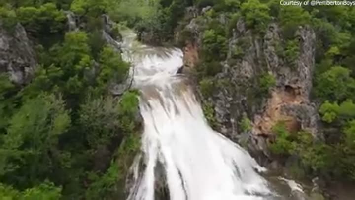
Turner Falls cascades over 340 million-year-old rock.
Hidden within the ancient Arbuckle Mountains, Turner Falls plunges **77 feet** into a natural swimming pool, making it Oklahoma's tallest waterfall. This impressive cascade is fed by Honey Creek, flowing year-round from natural springs. Geologically, the water tumbles over **340 million-year-old Ordovician limestone**, some of the oldest exposed rock in the region. This dramatic feature stands in stark contrast to the common perception of Oklahoma as flat.
Peaks, Plateaus, and Peculiar Formations
Black Mesa, Oklahoma's highest point, defies expectations.
Oklahoma's highest point, Black Mesa, rises to **4,973 feet** in the far western panhandle, presenting a landscape more akin to the American Southwest than the Great Plains. Geologically, it is part of the same system that extends through Colorado and New Mexico, sitting on the edge of the Colorado Plateau. Its dry, elevated terrain and volcanic rock formations offer a stark visual and geological departure from the typical Oklahoma prairie.

World's tallest hill is a matter of technicality.
Oklahoma lays claim to the "world's tallest hill," Cavanaugh Hill (near Poteau), because it rises **1,999 feet** from base to summit, just one foot shy of the arbitrary 2,000-foot cutoff often used to define a mountain. While the U.S. Geological Survey refers to it as Cavanaugh Mountain (its peak is over 2,300 feet above sea level), locals embrace the "hill" label for its unique claim, highlighting the fluid definition between hills and mountains.
Gloss Mountains are not mountains, but a geological typo.
Rising out of western Oklahoma, the "Gloss Mountains" are not true mountains but mesas composed of red rock and gypsum. Their distinctive appearance comes from a covering of **selenite**, a mineral that reflects sunlight, giving them a glass-like sheen. Early explorers called them the "Glass Mountains," but an 1800s map typo rendered the name as "Gloss," which has stuck ever since. These formations formed approximately **250 million years ago** when the area was an inland sea.
Arbuckle Mountains run unusually east to west.
Most mountain ranges in North America trend north to south, but Oklahoma's Arbuckle Mountains are an exception, running distinctively **east to west**. This unusual orientation is due to a separate tectonic event that occurred around **300 million years ago**, folding rock in a different direction than ranges like the Rockies or Appalachians. This unique geological alignment is visible in the horizontal ridge lines when hiking, making it one of the few places in the U.S. where terrain deviates from the typical pattern.
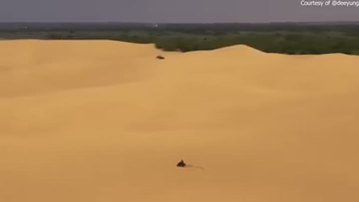
A genuine desert lies within northwestern Oklahoma.
In northwestern Oklahoma, Little Sahara State Park encompasses **1,600 acres** of authentic sand dunes, some reaching heights of up to **75 feet**. This desert landscape, devoid of red dirt or grass, formed thousands of years ago when the Cimarron River deposited vast amounts of sand during floods, which wind then sculpted into dunes. It offers a striking contrast to the surrounding flat prairie, providing a unique environment for activities like sandboarding and dune buggy riding.
Hundreds of caves honeycomb the state's underground.
Oklahoma boasts approximately **800 documented caves**, primarily formed in limestone and gypsum deposits. Over geological time, water has dissolved these soluble rocks, creating extensive underground systems. Some caves, like Alabaster Caverns, are large and publicly accessible, while others remain smaller and more remote. These subterranean environments serve as crucial habitats for various bat species and often contain archaeological evidence of early human activity, revealing a hidden side of Oklahoma's geology.
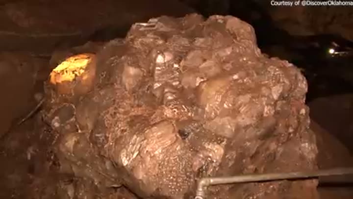
World's largest public gypsum cave is in Oklahoma.
Alabaster Cavern State Park hosts the world's largest gypsum cave open to the public. This cavern system formed within a thick gypsum layer deposited around **250 million years ago**, as water slowly dissolved the rock. The main cave extends about **three-quarters of a mile**, featuring high ceilings and wide passages. Gypsum caves are relatively rare due to the material's softness, making this cave's stability and accessibility particularly remarkable. It is also home to several species of bats.
Rare black alabaster found deep within state caverns.
Within Alabaster Cavern, beyond the typical white gypsum, are deposits of black alabaster, a material found in only a **few locations worldwide**. The distinctive dark coloration results from mineral impurities, giving it a unique appearance compared to standard alabaster. This geological rarity adds to the significance of the cavern, providing a subtle yet globally uncommon variation in its mineral composition, often overlooked by casual visitors but prized by geologists.
Oklahoma is a geographic anomaly, a canvas painted with ancient mountains, hidden deserts, and a water network more engineered than natural.
Water's Wild Ways
Oklahoma has more man-made lakes than any other state.
Oklahoma is home to over **200 man-made lakes**, surpassing every other U.S. state in this category. The vast majority of these reservoirs were constructed after the 1930s, largely in response to the Dust Bowl era when rivers dried up and water management became critical. Lakes like Texoma, Eufaula, and Keystone were engineered from scratch to control flooding, supply drinking water, and support recreation, transforming the state's dry, unpredictable water system into one of the most engineered networks in the country.
One major river confusingly carries two different names.
A significant river in Oklahoma experiences a curious identity crisis, known as the Beaver River in its western stretches and the North Canadian River as it flows eastward. Despite being the **same continuous waterway**, early mapping and settlement efforts led to different groups labeling it distinctively, and both names persisted. This split identity spans hundreds of miles, a geographic quirk reflecting historical naming conventions rather than any physical change in the river itself.
Lake Eufaula is slowly shrinking due to sediment buildup.
Lake Eufaula, covering over **100,000 acres**, is gradually diminishing as it fills with sediment. Soil eroded upstream is carried into the lake and settles at the bottom, steadily reducing its depth. This continuous buildup creates noticeably murky water in some areas. The scale of material needing removal to reverse this process is immense, meaning parts of the lake will continue to become shallower over time, an ongoing transformation changing the lake's character year by year.
Canadian River: a major waterway that often disappears.
The Canadian River, a major waterway spanning hundreds of miles across Oklahoma, paradoxically can cease to flow entirely in certain sections, especially during droughts. Instead of continuous water, wide stretches of sand become visible, punctuated only by small, isolated pools. This phenomenon occurs because parts of the river are heavily reliant on rainfall, and upstream water usage further reduces downstream flow. It remains a major river in designation, but its behavior often contradicts that status.
Blue River remains one of the state's last free-flowing rivers.
In a state dominated by engineered water systems, the Blue River stands out as one of Oklahoma's last free-flowing rivers, traversing approximately **140 miles** without major dams or reservoirs. This uninterrupted flow allows for natural processes such as sediment movement, seasonal flooding, and unimpeded fish migration. It offers a rare glimpse into how river systems function without significant human intervention, contrasting sharply with most other heavily controlled waterways in Oklahoma.
Ocean-born American eels migrate to landlocked Oklahoma.
Remarkably, Oklahoma's Blue River is home to American eels, a species that spawns in the Atlantic Ocean's **Sargasso Sea**. After hatching, these eels drift across the ocean, enter rivers along the East Coast, and eventually navigate the extensive Mississippi River system to reach inland streams in Oklahoma. This incredible migration spans thousands of miles, defying expectations for a landlocked state and showcasing the profound connectivity of global river systems.
Optima Lake: a reservoir that never adequately filled.
Optima Lake in the Oklahoma panhandle, completed in the late 1970s, notoriously failed to reach its anticipated capacity. This engineering miscalculation stemmed from insufficient consistent water flow in the Beaver River. Consequently, large portions of the lake bed remain dry most years. What was intended as a significant reservoir for recreation and water supply instead became a largely empty basin, demonstrating how critical accurate hydrological assessments are for major water projects.
Lake Texoma is a major lake shared by two states.
Lake Texoma, one of the largest reservoirs in the region, straddles the border between Oklahoma and Texas, formed by damming the Red River. Covering tens of thousands of acres, its management requires cooperation between both states, leading to occasional disagreements over water usage. Uniquely, it hosts striped bass, a fish typically found in saltwater, which have adapted to its freshwater conditions. It serves as a major recreational hub, attracting millions of visitors annually.
Oklahoma's lakes are uniformly filling with sediment.
It is not just Lake Eufaula; many of Oklahoma's lakes are experiencing a gradual reduction in depth. Rivers continuously transport sediment, dirt, and debris into reservoirs, where it accumulates on the bottom. This process slowly diminishes the lakes' water-holding capacity. Lakes like Overholser and Altus-Lugert necessitate ongoing maintenance to remove this buildup, but keeping pace with the natural process long-term is challenging. Without intervention, these vital water bodies will continue to lose capacity.
Submerged towns reappear from under Oklahoma's lakes.
When major reservoirs like Lake Texoma were created in the 1940s, entire valleys were flooded, submerging small communities, buildings, and cemeteries. While usually hidden underwater, these submerged towns can dramatically reappear during droughts when water levels drop significantly. Foundations, roads, and even old structures become visible again, serving as stark reminders that many of Oklahoma's lakes were built over places where people once lived, revealing a hidden layer of the state's history.
Keystone Lake primarily exists for flood control.
Keystone Lake, formed by damming the Arkansas River, was primarily constructed to prevent severe flooding in Tulsa. Before the dam, the river's unpredictable surges caused significant damage. The reservoir now effectively holds excess water during heavy rainfall, releasing it gradually to mitigate flood risks. While it also serves recreational purposes today, its fundamental design and operation remain centered on its crucial role in **flood control**, safeguarding downstream communities.
Weather's Fury
Oklahoma is the undisputed center of Tornado Alley.
Oklahoma sits squarely in the heart of Tornado Alley, averaging between **50 and 70 tornadoes** annually, though some years see significantly more, such as the **150+ recorded in 2024**. This extreme activity results from warm, moist air from the Gulf of Mexico colliding with cold, dry air from the Rockies, creating intense atmospheric instability. On May 3, 1999, the state experienced approximately **70 tornadoes in a single day**, including one with a record-breaking 321 mph wind speed.
Oklahoma is a lightning capital with high strike density.
Oklahoma experiences a high frequency of lightning, earning it the title of a lightning capital. The state's position within a zone where strong storms regularly form, particularly in spring and summer, leads to intense thunderstorms. The collision of warm, moist Gulf air and colder western air creates significant atmospheric instability. Certain counties record dozens of lightning strikes per square mile annually, a consistent pattern directly linked to the state's location amidst major weather systems.
Inland Oklahoma can receive hurricane-level rainfall.
Despite being landlocked, Oklahoma is susceptible to tropical-level rainfall. Storm systems originating in the Gulf of Mexico frequently travel inland, dumping immense amounts of moisture across the state. While these systems are no longer full hurricanes upon arrival, they can still produce extreme rainfall events. In 1973, a single storm dropped over **15 inches of rain in one day** in Enid, causing significant flooding. This combination of inland storm systems and residual tropical moisture contributes to Oklahoma's severe weather profile.
Hailstones can grow to extraordinary sizes here.
Oklahoma's severe thunderstorms are notorious for producing massive hail. Strong updrafts within these storms can suspend ice long enough for it to grow to unusual sizes before falling. In 2011, a hailstone measuring approximately **6 inches across** (roughly the size of a grapefruit) was recorded near Gotebo. Hail of this magnitude can cause extensive damage to vehicles, structures, and crops in mere minutes, underscoring the intensity of weather phenomena in this region.
Absurd temperature swings define Oklahoma's climate.
Oklahoma experiences dramatic temperature variations, ranking among the most temperature-variable states. The state has recorded a high of **120 degrees Fahrenheit** and a low of **-31 degrees Fahrenheit**, a staggering difference of over 150 degrees. These extreme swings are driven by Oklahoma's position between contrasting air masses, with few natural barriers to moderate them. Conditions can shift rapidly between extended heat waves in summer and severe freezes in winter, making the weather highly unpredictable.
This state changes completely depending on where you stand. Oklahoma has 12 distinct eco regions packed into a relatively small area, tying it for the most in the entire country.
Borders, Boundaries, and Hidden Realms
The Oklahoma panhandle was literally "no man's land."
For roughly **40 years**, the Oklahoma panhandle existed as a strip of land belonging to no one, a "no man's land." Measuring 34 miles wide, it lacked government, law enforcement, and official ownership. Texas relinquished it to avoid slavery restrictions, and surrounding territories declined annexation. This void made it a refuge for outlaws and cattle rustlers. Some settlers even attempted to establish their own unrecognized "Cimarron Territory," highlighting its unique status as one of America's few truly lawless regions.

Cimarron County uniquely touches five different states.
Cimarron County, located in Oklahoma's far northwestern corner, holds the distinction of bordering **five states**: Colorado, Kansas, New Mexico, and Texas. This makes it the only county in the U.S. connected to so many states. Despite this unique geographical position, it is sparsely populated, with fewer than **2,000 residents** spread across nearly 1,800 square miles. Its county seat, Boise City, is surrounded by vast, open land, offering minimal light pollution and profound isolation.
Oklahoma City is one of the largest cities by land area.
Oklahoma City sprawls over **600 square miles**, making it one of the largest cities in the U.S. by land area, surpassing metropolises like New York (305 sq miles) and Los Angeles (500 sq miles). This extensive footprint is a result of decades of strategic annexation. Consequently, the city blends urban development with surprisingly rural landscapes, featuring open land and even livestock within its official limits. Commutes can be unexpectedly long due to its vast, spread-out nature.
Red River border was once an international boundary.
The Red River, forming Oklahoma's southern boundary, once served as an international border between the United States and Mexico before Texas joined the Union. Standing on opposite banks literally meant being in different countries. Beyond its political history, the river also has a deep geological past; millions of years ago, it flowed in a different direction before tectonic changes rerouted its course. Today, it remains a state line, its role having shifted multiple times while maintaining its general path.
The 100th Meridian divides Oklahoma's climate zones.
An invisible yet profoundly impactful line, the **100th meridian**, bisects Oklahoma, marking a critical climatic shift. East of this line, the state receives sufficient rainfall to support agriculture without extensive irrigation. Westward, however, conditions become significantly drier, with rainfall dropping considerably, leading to changes in vegetation, soil color, and overall terrain. This meridian is one of the most important geographical boundaries in the U.S., shaping everything from ecosystems to agricultural practices within Oklahoma.
Cross Timbers forest forms a natural state divider.
A narrow, dense forest belt known as the Cross Timbers cuts north to south through Oklahoma, acting as a natural boundary. Historically, this forest, composed mainly of post oak and blackjack oak, was so thick that traversing it with wagons was nearly impossible for early settlers. It effectively separated the wetter eastern forests from the drier western plains. This unique forest type exists only in this region and parts of Texas, serving as a distinct ecological and historical dividing line that influenced early settlement patterns.
Ecosystems Unexpected
Oklahoma ties for most diverse ecosystems in the country.
Oklahoma boasts an astonishing **12 distinct ecoregions** packed into its relatively modest area, tying it for the most diverse in the entire country. Driving from the southeast to the northwest reveals a dramatic transition through swamps, pine forests, hardwood hills, vast prairies, and ultimately, arid, desert-like terrain. This extreme variation is driven by rainfall differences, with eastern Oklahoma receiving over **50 inches annually** while the panhandle gets only 15 to 20 inches, supporting a remarkable mix of plant and animal life.
Four distinct mountain ranges punctuate Oklahoma's landscape.
Contrary to the common perception of a flat prairie state, Oklahoma contains four separate mountain ranges: the Arbuckles, Wichitas, Ozarks, and Ouachitas. The Ozark and Ouachita regions, in particular, form one of the only major highland systems between the Rockies and the Appalachians. These elevated, forested areas offer a dramatic contrast to the plains, allowing travelers to transition from open grasslands to rolling hills and thick forests within just a few hours' drive.
The Ozarks extend surprisingly far into Oklahoma.
The distinctive Ozark region does not solely reside in Arkansas and Missouri; it also stretches into northeastern Oklahoma, creating a unique environment. This area features rolling hills, limestone formations, clear, spring-fed rivers, and dense forests. The cooler, clearer waters support activities like trout fishing, unexpected this far south. The terrain and geology here are consistent with the Ozarks found in neighboring states, bringing a different ecological character to Oklahoma.
Ouachita National Forest, a massive forested expanse.
Southeastern Oklahoma is home to a significant portion of the Ouachita National Forest, covering approximately **1.8 million acres**. This vast expanse features thick hardwood and pine forests, along with rolling hills that feel entirely distinct from the state's plains regions. The forest supports diverse wildlife, including black bears, and contains areas of older, less disturbed growth. It sits atop one of the region's oldest mountain systems, offering a landscape that defies typical Oklahoma expectations.
Tallgrass Prairie Preserve shows plains in original state.
The Tallgrass Prairie Preserve in Oklahoma offers a rare glimpse into the Great Plains' original ecosystem, protecting tens of thousands of acres of native prairie. Here, grasses can grow over **six feet tall**, and the environment is maintained by natural processes like fire and bison grazing. Bison have been successfully reintroduced and roam freely, recreating pre-settlement conditions. With most of the original prairie converted to farmland, this preserve is a vital testament to North America's ecological past.
Elk populations successfully reintroduced to Oklahoma.
By the late 1800s, elk were entirely extirpated from Oklahoma due to overhunting. However, in 1911, a small group, just a **handful of animals**, was reintroduced into the Wichita Mountains. This reintroduction proved remarkably successful, leading to a thriving population of over **1,000 elk** in the area today. It stands as one of the state's most successful wildlife conservation efforts, demonstrating how quickly a species can rebound given suitable conditions and dedicated management.
Wild alligators thrive in Oklahoma's southeastern swamps.
Oklahoma harbors established, breeding populations of wild alligators in its southeastern region, particularly in swampy areas near Broken Bow along rivers like the Red and Little River. This represents the **northernmost edge of their natural range**. Alligators survive Oklahoma's winters by entering a dormant state in mud. While generally smaller than their Louisiana counterparts, their presence is a surprising biological fact for a state not typically associated with these apex predators.
Oklahoma has unexpected, deep South-like swamps.
The southeastern corner of Oklahoma, particularly around McCurtain County, features swampy terrain reminiscent of the Deep South. This environment is characterized by bald cypress trees and slow-moving waters, supporting species like the aforementioned alligators, which are unexpected this far inland. The region is noticeably wetter, warmer, and more humid than the rest of the state, providing a completely different ecosystem compared to the plains or prairie landscapes commonly associated with Oklahoma.
Rainfall gradients change dramatically across the state.
Oklahoma experiences a rapid shift in annual rainfall across its breadth. Eastern Oklahoma can receive over **50 inches annually**, supporting dense forests and lush vegetation. However, as one moves westward, that figure plummets to under **20 inches** in some areas, a significant transition over a relatively short distance. This drastic gradient influences everything from agricultural viability to ecosystem composition, visibly altering the landscape, with trees thinning and grasses shortening as the environment becomes progressively drier.
Human Footprints on the Land
Oklahoma's red dirt has a distinct, unrelated origin.
Much of central Oklahoma is characterized by its vivid red soil and rock, a result of iron-rich minerals oxidizing over time. However, the state's name, "Oklahoma," does not derive from this distinctive color. It originates from Choctaw words meaning "**red people**," chosen in the 1800s to refer to the indigenous nations relocated to the region. The coincidence of the land's color matching the state's name is merely that, a happenstance that often leads to incorrect assumptions about its etymology.
More earthquakes than California, for a few years.
Between 2009 and 2015, Oklahoma experienced an unprecedented surge in seismic activity, recording hundreds of magnitude **3.0+ earthquakes**, surpassing California's numbers in some years. This dramatic increase was primarily linked to the wastewater injection practices of oil and gas operations, which heightened underground pressure along fault lines. The largest event, a magnitude **5.8 quake in 2016**, caused significant damage, highlighting how quickly human activity can impact geological stability, though regulations have since reduced frequency.
An Oklahoma town was accidentally bombed by the U.S. military.
In 1943, during World War II training, a U.S. bomber crew mistakenly targeted Boise City in the Oklahoma panhandle instead of their designated practice area. They dropped several bombs in the early morning, fortunately causing no fatalities. The crew had misidentified the town's layout while navigating at night. This remains the **only recorded instance** of a continental U.S. town being accidentally bombed by its own military during the war, a bizarre footnote in local history.
Gas and saltwater seep naturally from the ground.
In certain regions of Oklahoma, the ground exhibits natural seeps where gas and saltwater rise to the surface, appearing as bubbling pools. These phenomena are often connected to historical oil and gas activity, where underground pressure builds and escapes through existing geological pathways. In some cases, the escaping gas, primarily methane, can even ignite if exposed to a flame. These seeps are an unusual side effect of the state's extensive history with energy production.
Oklahoma once experienced a statewide seismic pulse.
In 2019, sensors across Oklahoma detected repeated, rhythmic seismic pulses, an unusual pattern that initially puzzled researchers. These were later traced to controlled explosions at a military facility. Under specific atmospheric and ground conditions, the vibrations traveled far beyond expectations, creating a consistent, statewide signal. This peculiar event demonstrated how environmental factors can dramatically alter the propagation of seismic energy, catching attention across the entire state.
Oklahoma is geographically larger than many sovereign nations.
At nearly **70,000 square miles**, Oklahoma is significantly larger than many sovereign countries, including Portugal and Austria, and comparable in size to Ireland. Driving across the state, particularly from the panhandle to its eastern border, can take many hours. Despite its considerable footprint, Oklahoma is often geographically underestimated, overshadowed by larger, more recognized states. On a global scale, however, its sheer land area is far from small, defying common perceptions.
Oklahoma, then, is no mere flyover state. It is a land of profound geographic contradictions and unexpected wonders, a testament to the fact that the world's most compelling stories are often found where we least expect them. From billion-year-old rock formations to modern-day seismic anomalies, from ocean-dwelling eels in landlocked rivers to deserts blooming in the plains, its landscape is a living plot twist. This is the real Oklahoma, a place far stranger and more spectacular than any map or school lesson might suggest, inviting us all to look closer at the geographic marvels hidden in plain sight.


