Beyond the familiar fifty states, the United States extends its reach across a scattering of islands and atolls, often overlooked yet geographically astounding. These remote territories, from the Caribbean to the far Pacific, are not mere footnotes on a map, but rather a collection of geological marvels, ecological anomalies, and historical crossroads. Imagine an island where the tides defy convention, a rainforest older than the nation itself, or a piece of American soil perched directly above the second deepest chasm on Earth. These are the places where the planet's raw power and intricate beauty reveal themselves in ways that challenge our conventional understanding of American geography, proving the world, and indeed our own country, is far stranger and more spectacular than most schoolbooks suggest.
The Deepest Cuts: Submerged Giants and Abyssal Frontiers
The vastness of America's territorial reach plunges to the very bottom of the ocean, encompassing some of Earth's most profound depths. While the Challenger Deep, the deepest point on the planet, lies within Micronesian waters, just a few miles away, the United States controls the Serena Deep. This colossal chasm, the second deepest point on Earth, plunges more than 35,000 feet. To put this into perspective, if Mount Everest were dropped into the Serena Deep, its summit would still be buried under over a mile of water. This entire area forms a protected national monument, a silent, underwater wilderness larger than many independent nations, largely unknown to the very populace it serves.
The Mariana Trench itself, a geological feature often imagined as a distant, isolated phenomenon, is predominantly American territory. This gargantuan trench stretches for over 1,580 miles, a length more than five times that of the Grand Canyon. Unlike its terrestrial counterpart, which draws some five million visitors annually, the Mariana Trench sees virtually none. Access requires specialized submarines capable of withstanding pressures that would crush any standard vessel, making trailheads, visitor centers, and gift shops impossible concepts. The National Park Service promotes this incredible monument through off-site programs, acknowledging its status as one of America's most impressive, yet inaccessible, protected wonders.
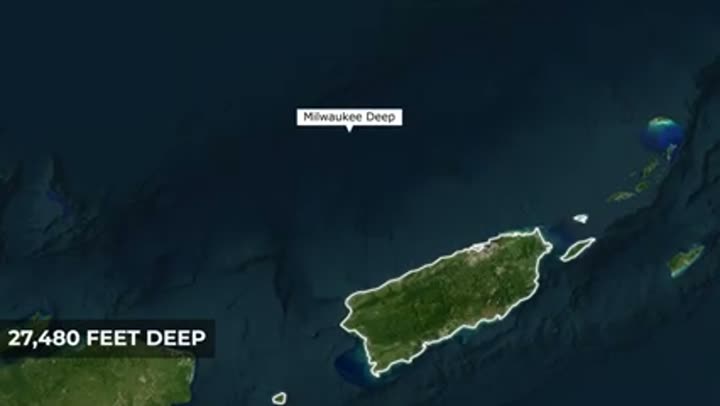
Not to be outdone by its Pacific counterpart, the Atlantic Ocean also harbors a profound American-controlled abyss. Just 76 miles north of Puerto Rico lies the Milwaukee Deep, the deepest point in the Atlantic Ocean. This trench plunges an astonishing 27,480 feet, a vertical drop of over five miles. Were Mount Everest to be placed within the Milwaukee Deep, its base would rest on the bottom, with its peak still some 1,500 feet below the ocean's surface. In 2018, explorer Victor Vescovo made history by becoming the first person to solo pilot a submarine to its bottom, underscoring Puerto Rico's position on the very edge of the Atlantic's extreme deep-sea frontier.
The island of Guam, often perceived as a relatively flat landmass, is in fact the visible peak of a colossal underwater mountain. Measuring from the floor of the nearby Challenger Deep to the summit of Guam's Mount Lam, one encounters a vertical rise of over 37,000 feet. This makes it roughly 8,000 feet taller than Mount Everest, if measured from base to peak. Guam, therefore, is not merely a small island, but the very tip of a rock skyscraper, largely hidden beneath the waves, with the world's deepest abyss and its tallest seafloor mountain sitting in remarkable proximity.
Compounding this geological intensity, Puerto Rico itself is slowly being drawn into the depths. Geological data, including GPS measurements and seafloor maps, indicate that the island's northern coast is gradually tilting into the abyss. A massive limestone platform is being dragged downward as the Atlantic plate tears and sinks, creating a powerful suction effect. This phenomenon is so significant that it produces the lowest gravity anomaly on the planet, a dip in gravity so pronounced it can disrupt ship navigation systems. The island shifts sideways at approximately 2 centimeters a year, its northern edge locked in a slow, relentless tug of war with the Atlantic's deepest point. Puerto Rico is quite literally being swallowed by a trench.
Guam, therefore, is not merely a small island, but the very tip of a rock skyscraper, largely hidden beneath the waves, with the world's deepest abyss and its tallest seafloor mountain sitting in remarkable proximity.
Islands Forged in Fire: Volcanic Births and Geological Tempers
The Pacific territories bear the fiery scars and ongoing creation of intense volcanic activity. Deep beneath the western Pacific, within US waters, lies the Mariana Arc of Fire, a chain of 21 undersea volcanoes. This arc harbors some of the most bizarre environments on Earth. At Daikoku Seamount, scientists have discovered a bubbling pool of molten liquid sulfur, a substance so rare it has only been observed elsewhere on Jupiter's moon, Io. Nearby, the Northwest Rota volcano hosts the Champagne Vent, named for its effervescent sprays of nearly pure liquid carbon dioxide. Despite the scalding heat and bone-dissolving acidity, these extreme environments teem with life, including mussels and flatfish, thriving in one of the planet's most toxic neighborhoods.
American Samoa, too, owes its existence to this powerful geological engine. On Ta'u Island, near vertical sea cliffs rise 3,000 feet straight from the ocean, among the tallest coastal cliffs globally. These dramatic formations are the result of an ancient volcanic collapse that sent half the island sliding into the sea, leaving behind a wall of rock so steep and remote that much of its coastline remains unmapped on foot. This wild stretch is part of the National Park of American Samoa, noteworthy for being the only US national park located entirely in the Southern Hemisphere.
Just 25 miles off American Samoa's coast, a massive underwater volcano named Va'aulu is actively building itself. Rising 14,300 feet from the seafloor, taller than most mountains in the continental US, its summit currently remains about 1,900 feet below the surface. However, Va'aulu is growing rapidly. A volcanic cone named Nafanua within its crater shot up nearly 1,000 feet in just four years, sometimes growing eight inches a day. Fueled by the same geological hotspot that formed the Hawaiian Islands, Va'aulu is on track to breach the ocean surface and become America's newest island, erupting into existence rather than being bought or claimed.
The Northern Mariana Islands, while appearing idyllic, are perched on one of Earth's most volatile geological seams. Since 2000, the territory has experienced six volcanic eruptions, including a 2003 blast on Anatahan that necessitated a permanent evacuation. Further north, Pagan Island hosts one of the Pacific's most active volcanoes, constantly emitting steam and ash. These islands were not merely formed near the Mariana Trench; they were forged by it, created by the Pacific plate grinding beneath the Philippine plate. The land here is in a continuous state of simultaneous creation and destruction, a paradise with a fiery temper.
This same geological engine that built Hawaii is responsible for American Samoa. Both archipelagos, though separated by 2,500 miles, were formed by hotspots, stationary plumes of magma that burn through the moving Pacific plate. As the plate drifts, older islands move away, and new ones form over the persistent thermal plume. In American Samoa, Ta'u is the current focus of this activity, but the true story unfolds 28 miles east at Va'aulu, the submerged volcano still building towards the surface. The very same processes that sculpted Honolulu are still actively at work.
The volatility beneath these islands is not merely historical. In 1866, an underwater eruption between Ta'u and Olosega blasted ash and gas 2,000 feet into the sky, poisoning the air over nearby villages and turning the sea sulfur yellow from the mass death of fish. Then, silence for over a century. However, in 2022, hundreds of earthquakes rocked the Manua Islands, confirming that magma was once again moving deep underground. This proved that the Samoan hotspot had not gone quiet, but had simply been waiting. These islands do not rest on stable rock; they are precariously perched on a volatile geological spring that could erupt at any moment.
Where Life Finds a Way: Remarkable Ecosystems and Bioluminescent Wonders
The US Virgin Islands offer a unique ecological crossroads. On St. Thomas and St. John, the north shore faces the colder, rougher Atlantic, while the south shore dips into the calm, turquoise Caribbean Sea. The largest island, St. Croix, sits 40 miles further south, fully within the Caribbean. This means two distinct marine ecosystems collide within a single American territory, allowing visitors to swim in both before lunch. However, one of these unique sites, Buck Island, is literally shrinking. Rising sea levels and warming oceans are eroding the reef faster than it can rebuild, with the sea creeping up roughly an inch every decade. Its world-famous Turtle Beach is being reshaped in real time, a national monument slowly being reclaimed by the very ocean it sits in.
Halfway between Puerto Rico and the Dominican Republic, Mona Island rises dramatically from the sea, a massive limestone fortress. With zero permanent residents, Mona boasts some of the most alien geography in all US territory. Nicknamed the “Galapagos of the Caribbean,” its vertical cliffs shelter the Mona ground iguana, a four-foot-long prehistoric lizard found nowhere else. Below the surface, the island is a Swiss cheese of over 200 caves, containing thousands of ancient Taino drawings. With no hotels, no running water, and no roads, Mona remains a literal time capsule of the pre-human Caribbean, untouched and pristine.
Out of 193 million acres in the US National Forest system, only one qualifies as a true tropical rainforest. This is El Yunque, located in northeastern Puerto Rico, covering 28,000 acres of dense, dripping jungle. It hosts 240 tree species, 23 of which are endemic, found nowhere else on Earth. Its peaks receive over 200 inches of rain a year, feeding rivers that supply a fifth of Puerto Rico's drinking water. Remarkably, El Yunque has been protected since 1876, when the Spanish crown declared it a reserve, making it one of the oldest protected forests in the entire Western Hemisphere, predating the US National Forest System itself.
The extreme rarity of some species underscores the fragility of these ecosystems. In 1975, only 13 Puerto Rican parrots remained alive, clinging to survival in the canopy of El Yunque. These parrots, known locally as iguaca, are the only native parrot species in all US territory. Decades of recovery efforts, including breeding programs and habitat protection, have slowly reversed their decline. Today, over 900 parrots fly through the treetops of El Yunque and Rio Abajo. While still critically endangered, their recovery demonstrates that even from the brink of extinction, a species can claw its way back.
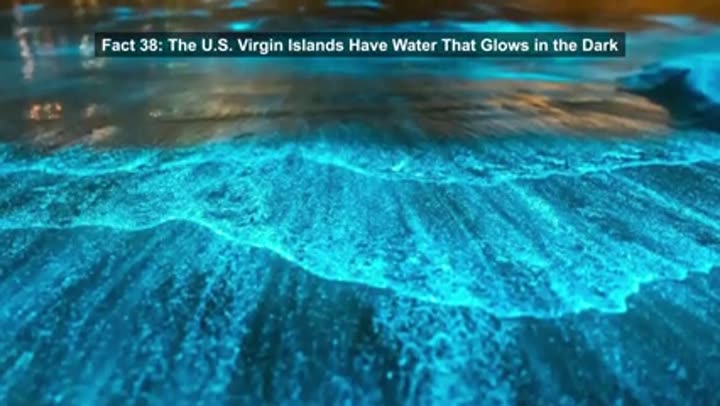
The US Virgin Islands are home to a truly otherworldly phenomenon: water that glows in the dark. Tucked inside a US national park on St. Croix is Salt River Bay, one of only seven full-time bioluminescent bays in the entire Caribbean. Unlike most glow spots that flicker with the seasons, this one blazes electric blue 365 days a year. The water is teeming with tiny dinoflagellates and neon green comb jellies. Dip a paddle in, and the surface erupts in light. It is the only permanently bioluminescent bay protected by the US National Park Service, offering one of the most unreal sights without ever leaving American soil.
Puerto Rico itself holds a global monopoly on glowing water, with three of the world's five permanent bioluminescent bays. The brightest is Mosquito Bay on Vieques Island, where microscopic organisms flash neon blue the instant anything disturbs them, turning every paddle stroke into a trail of light. These rare ecosystems require a perfect cocktail of deep mangroves and narrow channels to sustain the organisms. Get the mix wrong, and the glow disappears. Puerto Rico, against all odds, managed to get it right three times. Adding to its ecological diversity, Puerto Rico, roughly two-thirds the size of Connecticut, packs the climate diversity of a continent into just 100 miles. Driving across the island reveals six distinct ecological zones, from humid subtropical plains to cool cloud-wrapped mountains, and even a desert-like dry forest.
Indeed, a desert can be found within this tropical island. Drive to Puerto Rico's southwestern tip, and the palm trees vanish, replaced by towering cacti, cracked earth, and bone-dry air. This is the Guanica dry forest, which receives as little as 30 inches of rain per year, making it drier than parts of Arizona. This arid pocket exists because Puerto Rico's central mountains block moisture-rich trade winds, creating a tiny rain shadow just miles from a tropical rainforest. Despite its dryness, Guanica is a UNESCO biosphere reserve and one of the last intact subtropical dry forests on Earth, a desert hiding within a tropical island.
Far across the Pacific, approximately 1,000 miles south of Hawaii, lies Palmyra Atoll, a tiny ring of tropical land that is legally the most American place you have never heard of. It is the only incorporated US territory, meaning the full US Constitution applies there, just as it does in Washington D.C. However, nobody lives there. Palmyra is drenched with 175 inches of rain a year, transforming it into a thick jungle sponge surrounded by turquoise water. Its only permanent residents are seabirds, land crabs, and rotating teams of scientists. This pristine atoll's coral reefs are remarkably healthy, holding nearly three times the coral diversity of the entire Caribbean. What is even more absurd is that sharks and apex predators constitute 56 percent of the fish population, a stark contrast to most reefs where these large predators were fished out long ago. Scientists regard Palmyra as a gold standard, a living snapshot of the Pacific before human intervention.
Deep beneath Puerto Rico's northwestern hills, the Rio Camuy has been carving for millions of years. This underground river, one of the largest in the Western Hemisphere, has hollowed out a labyrinth of over 220 caves and sinkholes, some vast enough to swallow a 20-story building. Formal exploration only began in 1958, and hundreds of these caves remain completely unmapped. While Puerto Rico attracts 7.5 million visitors annually, mostly to its beaches, an entire hidden world of towering subterranean caverns lies largely untouched beneath their feet.
A Tapestry of Time: Echoes of History and Cultural Crossroads
Guam's tides play by their own rules, unlike most predictable coastlines with their two high and two low tides. The island experiences a mixed semidiurnal tide, where the two daily high tides can differ wildly in height. On some days, this difference is so extreme that one tidal cycle virtually disappears, leaving only a single high and a single low. This unpredictable pattern is a result of Guam's position in the western Pacific, where the ocean basin's shape and the moon's gravitational pull create swirling currents. For swimmers, this means a calm, shallow reef can transform into a maze of hidden currents in mere minutes.
On St. Croix, a living monument to history stands against all odds. The Grove Place baobab, a 300-year-old African savannah tree, grows thousands of miles from its native continent. Its seeds were carried across the Atlantic by enslaved Africans during the Middle Passage, taking root in Caribbean soil and refusing to die. This resilient "tree of life" survived the 1848 rebellion, the 1878 Fireburn revolt, and countless hurricanes over three centuries. Today, it is a national monument, a testament to endurance and a piece of Africa permanently planted in American soil.
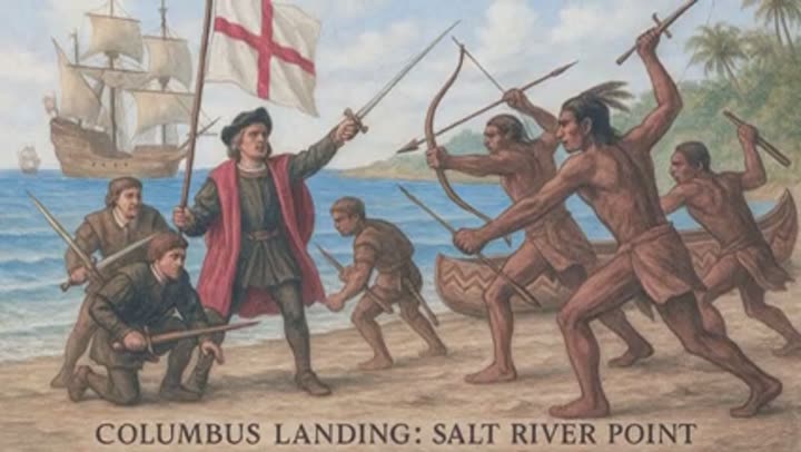
Salt River Bay, though a peaceful glowing paradise today, holds a pivotal place in American history. In 1493, during his second voyage, Christopher Columbus made his only known landing on what is now US soil at this very bay. The encounter did not go well. At a spot later named the Cape of the Arrows, his crew met Kalinago warriors who were decidedly uninterested in being "discovered." This confrontation marked the first documented armed resistance against European colonizers in future US territory. Beyond this single violent encounter, the bay encapsulates over 2,000 years of layered history, from early Taino villages to colonial-era forts, all packed into one small stretch of coastline where the water glows at night and history runs deep.
The geographical bookends of the United States are not found within the 50 states. The true easternmost point of the US is Point Udall, a sun-drenched cape on St. Croix in the US Virgin Islands. Traveling 9,500 miles west across the Pacific, one encounters the westernmost point, also named Point Udall, this one on Guam. Both points are named after brothers from the same political dynasty, a curious coincidence that places the extremities of America on two small islands, one in the Caribbean and one in the Western Pacific, quietly holding down the edges of a country whose vastness few truly comprehend.
A unique cultural quirk awaits visitors to the US Virgin Islands: driving on the left side of the road. It is the only place under the US flag where traffic flows this way. What makes it truly bizarre is that almost every car on the islands is an American import, meaning the steering wheel is also on the left. This results in drivers navigating on the left side of the road, while sitting on the left side of the car, hugging the outside shoulder instead of the center line. Local legend attributes this to 19th-century donkeys refusing to switch sides, though British colonial influence is the more probable explanation. Regardless, it remains an enduring part of the islands' distinct charm.
American Samoa stands alone as the only inhabited US territory in the Southern Hemisphere, located 14 degrees below the equator. Though tiny, at just 76 square miles spread across five volcanic islands, its influence on the ocean is immense. Its exclusive economic zone (EEZ) stretches nearly 118,000 square miles, roughly the size of Oregon with some additional acreage. With 90 percent of its land still covered in untouched rainforest, it is one of the most pristine and least visited places flying the American flag.
A surprising fact about American Samoa is that people born there are classified as US nationals, not citizens. They can live and work anywhere in the country and carry an American passport, but they cannot vote in federal elections unless they undergo the full naturalization process, the same one used by immigrants. In a unique twist, local leaders have actively fought to maintain this status, fearing that automatic citizenship could open the door to federal rules that might threaten their traditional culture and communal land system. Thus, American Samoa remains the only place under the US flag where people have chosen to remain nationals, not because citizenship was denied, but because protecting their way of life was deemed more valuable.
The Samoan Islands present a curious case of time travel. American Samoa and the independent nation of Samoa share the same culture, language, and history, yet they live an entire day apart. In 2011, Samoa shifted across the International Date Line to align with Australia's business week, but American Samoa did not make the switch. Consequently, two island groups just 50 miles apart are separated by a full 24 hours. When it is Sunday morning in American Samoa, it is already Monday morning in Samoa, meaning one can celebrate a birthday, take a short flight, and relive the entire day from scratch.
Palmyra Atoll, the only incorporated US territory, was notably excluded when Hawaii became the 50th state in August 1959. Despite having been part of the territory of Hawaii for decades, the atoll was omitted from the statehood bill, rendering it a legal orphan. After World War II, its private owners, the Fullard-Leo family, successfully sued the US Navy to reclaim their atoll. Palmyra then cycled through private hands for years until 2000, when The Nature Conservancy purchased the entire atoll for $30 million, not for development, but to preserve it as one of Earth's last pristine wildernesses.
In the summer of 1962, a team of 40 people stationed on Palmyra Atoll witnessed a sight no human was ever meant to see: a sunset that transformed into a sunrise. This was Operation Dominic, a series of US nuclear tests conducted in the upper atmosphere. The headline event, Starfish Prime, involved a 1.4 megaton warhead detonated 250 miles above the Pacific. The explosion created a man-made aurora that illuminated the sky for seven minutes, turning night into a blazing, unnatural day. The fallout was not just visual; the electromagnetic pulse knocked out streetlights and phone lines 900 miles away in Hawaii and fried early orbiting satellites. The team on Palmyra recorded data from what was essentially a front-row seat to a man-made apocalypse, with the results remaining classified for years.
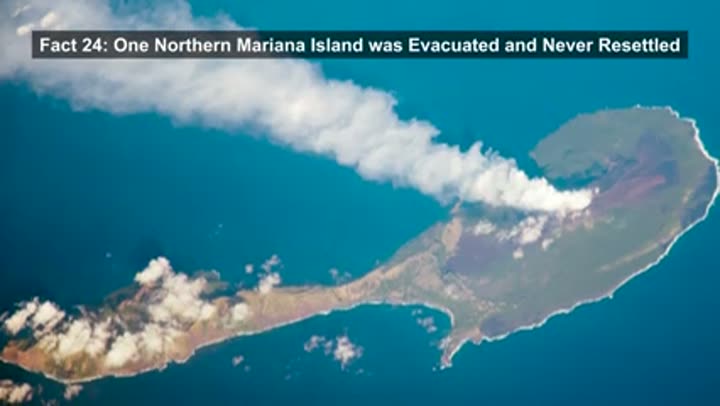
Pagan Island, in the Northern Mariana Islands, was once a thriving community of farmers and fishermen. This came to an abrupt end on May 15, 1981, when the northern volcano erupted, forcing every resident to flee overnight. For 30 years, Pagan remained empty, jungle vines reclaiming homes and feral cattle roaming abandoned roads. Though the US military considered using it for bombing practice, local opposition thwarted the plan. Today, Pagan is officially uninhabited, though a handful of individuals live off the grid, surviving in the shadow of a still-smoking volcano. Adding to the unique markers, Guam, due to its far western position in the Pacific and its location on "tomorrow's side" of the International Date Line, catches the sunrise before any other piece of American territory. The mainland will not see daylight for hours, nor will Hawaii. Guam is over 3,800 miles from the nearest US state and nearly 6,000 miles from the continent, making it the most remote corner of America by almost any measure, and every single morning, it is the first place in the country where a new day begins.
The US Virgin Islands were literally bought off the shelf. In 1917, the US paid Denmark $25 million in gold coins, a sum equivalent to over $635 million today, or roughly $5 billion by gold value. The urgency stemmed from Washington's fear that Germany might seize the islands and establish a U-boat base to choke off the Panama Canal. Every March 31st, locals commemorate Transfer Day, marking the last time the Danish flag was lowered. This transaction represented America's last territorial purchase and included a secret clause: the US relinquished all future claims to Greenland to finalize the deal.
On the coast of Saipan, in the Northern Mariana Islands, 112 steps descend into a collapsed limestone cavern filled with seawater and electric blue light. This is the Grotto, considered one of the best cavern dive sites globally. Sunlight streams through three underwater openings to the open ocean, flooding the cave with an otherworldly glow. Divers encounter reef sharks, sea turtles, and eagle rays within the cavern, which plunges 70 feet deep. It was carved over millennia by the same tectonic forces that built the Mariana Trench to the east, a geological cathedral hidden in plain sight on a tiny Pacific island.
American Samoa celebrates a national holiday unique among US territories and states. Every April 17th, Flag Day marks the date in 1900 when the territory was formally ceded to the United States, treated as the year's most significant event. The celebration features traditional Samoan dance, fire knife performances, boat races, and oratory competitions. It is the day when American Samoan identity is fully displayed, a territory that maintains US nationality but not citizenship, celebrating an annexation about which its own government holds complex feelings. It is patriotic, cultural, and entirely unique.
The US Virgin Islands were literally bought off the shelf. In 1917, the US paid Denmark $25 million in gold coins, a sum equivalent to over $635 million today, or roughly $5 billion by gold value.
Paradise Under Siege: Ecological Battles and Unintended Consequences
The Puerto Rico Trench, a powerful geological feature, is not merely a deep hole but also a significant seismic hazard. The collision of the North American and Caribbean tectonic plates warps the Earth intensely, creating a fault capable of triggering magnitude 8.0 earthquakes. Scientists warn that such an event could unleash a catastrophic tsunami across the entire Caribbean. This is not hypothetical; in 1918, the San Fermin earthquake generated a 20-foot wave that devastated Puerto Rico's west coast. The trench also features the strongest negative gravity anomaly on the planet, where an enormous slab of thick crust pulls the ocean surface downward, creating a dip so significant it can actually disrupt ship navigation systems.
Puerto Rico experiences hundreds of small earthquakes annually, mostly unnoticed. However, on January 7, 2020, a magnitude 6.4 earthquake struck the southwest coast, collapsing homes and causing weeks-long power outages. Seismologists, however, consider this a mere warning shot. Since 1988, they have cautioned that a magnitude 7.5 or higher quake is overdue. The true threat lies in the Puerto Rico Trench to the north, a subduction zone capable of triggering a magnitude 8.0 earthquake and a devastating tsunami across the entire Caribbean. The 2020 quake served as a wake-up call, but the "big one" has yet to arrive.
Sometime after World War II, a single brown tree snake inadvertently slipped onto Guam, likely stowing away in military cargo from the Admiralty Islands. What followed was one of the worst ecological disasters in US history. Guam's native birds had evolved for millions of years without snake predators, possessing no instinct to flee or defend themselves. Consequently, 12 species were wiped out, nine of which are now globally extinct, permanently erased from the planet. The Guam flycatcher, the Guam rail, and the Rufous fantail, among others, were gone from the island by the 1980s. One accidental stowaway, tucked inside a shipping crate, rewrote the entire biological history of a US territory.
The ecological impact of the brown tree snakes extended beyond birds. These skilled climbers discovered that power lines made excellent highways. They would crawl into transformers, bridge live wires, and cause short circuits. At their peak, they were responsible for nearly 200 blackouts a year across Guam, accumulating over 1,600 outages in just two decades. The Guam Power Authority has implemented various countermeasures, including barriers, traps, and constant monitoring, yet the snakes still cause approximately 150 outages annually. A single invasive species has, quite literally, kept an entire US territory in the dark for decades.
The ripple effects of the brown tree snake invasion continue to unfold. The eradication of Guam's bird population led to an explosion in insect numbers, as the birds were no longer there to control them. More insects, in turn, meant more food for spiders. Researchers comparing Guam to nearby snake-free islands found spider populations to be absurdly higher on Guam, with some estimates suggesting 40 times more spiders. Furthermore, birds play a crucial role in seed dispersal. Without them, Guam's native trees can no longer spread effectively; seeds simply fall and remain beneath the parent tree. Consequently, the forest itself is slowly shifting in composition and changing shape, all due to one uninvited reptile that hitched a ride in a cargo hold 80 years ago.
In a bizarre and high-tech effort to combat the brown tree snake problem, the US government is literally parachuting poison mice from helicopters over Guam. This sounds like a rejected movie script, but it is a real operation. Using an automated aerial delivery system, the USDA launches thousands of dead mice, each fitted with a tiny biodegradable streamer designed to snag in the forest canopy, precisely where brown tree snakes hunt. Each mouse is injected with acetaminophen, a common pain reliever, which happens to be uniquely lethal to these snakes while harmless to nearly everything else. It stands as one of the strangest military operations in US history, with a reptile as the primary enemy.
The Edges of Empire: Far-Flung Outposts and Strategic Significance
Wake Island, despite its name suggesting a single point, is actually a V-shaped atoll composed of three tiny islands: Wake, Wilkes, and Peale, connected by narrow causeways around a central lagoon. With no indigenous population and no natural freshwater, access is restricted, requiring high-level military clearance. The US Air Force utilizes it as a missile defense test site and emergency runway, making it one of the most restricted places on Earth. While it was the site of a brutal battle in 1941, today it serves as a silent, 2.5 square mile military sentinel in the middle of the Pacific.

The United States maintains sovereignty over various tiny specks of coral that barely clear the waves. Islands like Howland, Baker, and Jarvis are flat, sunbaked sandbars. Kingman Reef is mostly submerged at high tide. Johnston Atoll, contaminated by decades of nuclear testing and chemical weapons disposal, is now a forbidden wildlife refuge. Individually, these islands might seem worthless. However, each one generates a 200-mile exclusive economic zone. When combined, these seemingly forgettable coral dots allow the US to control millions of square miles of the Pacific Ocean, transforming them into anchors of one of the largest maritime empires on the planet.
Guam, despite its tropical paradise image, is significantly militarized. Roughly a third of the island belongs to the US military, with Naval Base Guam and Andersen Air Force Base dominating the landscape. In recent years, the Pentagon has invested billions more, including the construction of Camp Blaz, the first new Marine Corps base built in nearly 70 years. For Guam's 181,000 residents, fighter jets and military convoys are simply part of daily life. Strategically positioned near some of the most sensitive flashpoints in the Pacific, this tiny island punches far above its weight as one of America's most critical military assets.
Ofu Beach, located in American Samoa, is consistently ranked among the most beautiful beaches on Earth, yet it remains largely deserted. Visiting this corner of the National Park of American Samoa entails a six-hour flight from Honolulu, a small prop plane to the outer islands, and often a local fishing boat for the final leg. While the Great Smoky Mountains National Park attracts 12 million visitors annually, this park receives fewer than 25,000 visitors. This extreme remoteness safeguards rare paleotropical rainforest and untouched coral reefs. It is a 5,000-mile journey, and that very distance is precisely why this paradise remains pristine.
Beyond the Map: The True Scale of America's Oceanic Domain
Here is the fact that truly ties it all together: the US territories give America more ocean than land. If one were to combine every square mile of Puerto Rico, Guam, American Samoa, and all other US territories, the total land area would amount to roughly 4,000 square miles. This is not a substantial landmass. However, each of these islands generates a 200-nautical-mile exclusive economic zone. When aggregated, these zones grant the United States the largest oceanic jurisdiction on the planet, encompassing over 4 million square miles. In 2024, a massive seabed mapping project added a California-sized chunk to America's underwater claim. These tiny, scattered territories are the anchors of an American maritime empire larger than the entire US landmass, a remarkable achievement for a few specks on the map.
The geography of the US territories is a masterclass in the unexpected, a collection of plot twists that reveal a world far stranger and more intricate than our school lessons ever conveyed. From the deepest ocean trenches to volcanoes birthing new land, from islands where time itself bends to ecosystems fighting for survival, these are the forgotten corners of America that redefine what "American" truly means. They are a testament to the planet's relentless geological forces and the surprising resilience of life, reminding us that the most incredible stories often lie just beyond the familiar, in the wild, untamed edges of our own map.


