Minnesota, often pictured as a land of placid lakes and gentle prairies, hides a geographic personality far more dynamic than its tranquil reputation suggests. Beneath its calm surface lie ancient volcanic scars, meteor impact sites, and a continental divide that sends a single raindrop on a journey to three different oceans. This is a state where glaciers skipped entire regions, where rivers flow north, and where the land itself seems to defy conventional expectations, offering a landscape that is both beautiful and wildly unpredictable.
Waters Unbound and Hidden Depths
A triple divide sends water to three oceans.
Near Minnesota's Iron Range sits the Hill of Three Waters, a rare triple continental divide. Rain falling here can journey to the Arctic Ocean via Hudson Bay, the Atlantic via the Great Lakes, or the Gulf of Mexico via the Mississippi River, an unusual convergence of major drainage basins.
A waterfall that visually swallows half a river.
At Devil's Kettle Falls on the Brule River, half the water plunges into a deep, perfectly round hole and seemingly vanishes. For decades, its destination was a mystery, but in 2017, hydrologists confirmed the water flows through underground fractures and rejoins the river downstream, creating a captivating optical illusion.
America's largest bog once served as a bombing range.
Northern Minnesota's Big Bog spans roughly 500 square miles, making it the largest peatland in the lower 48 states. Its remote, difficult terrain led the US military to use it as a bombing range from 1947 to 1953, with aircraft dropping one-ton bombs to create artificial ponds.
A vanished waterfall dwarfed Niagara by far.
Downtown St. Paul sits above the remnants of a colossal ice age waterfall, formed by meltwater from Glacial Lake Agassiz. This ancient cascade was nearly half a mile wide and 175 feet tall, significantly larger than Niagara Falls, and carved the Minnesota River Valley before retreating and disappearing.
The state boasts far more than 10,000 lakes.
Minnesota's famous nickname significantly understates its aquatic abundance. The state is home to 11,842 lakes larger than 10 acres, covering nearly 17% of its surface. This dense freshwater network means you could visit a new lake every day for over 30 years and still miss some.
More shoreline than three ocean states combined.
Minnesota surprisingly claims more shoreline than California, Florida, and Hawaii combined, totaling approximately 90,000 miles from its intricate network of lakes and rivers. Even counting only lakes over 10 acres, the state still boasts about 44,000 miles of freshwater coast.
You can step across the mighty Mississippi's source.
At Itasca State Park, the Mississippi River begins its epic journey in an unexpectedly humble fashion. Here, America's most famous river is narrow enough to step across in a single stride, marked by a simple log where water gently flows out of Lake Itasca.
Minnesota's tallest waterfall is half Canadian.
High Falls on the Pigeon River, plunging 120 feet, stands as Minnesota's tallest waterfall. It straddles the international border with Ontario, meaning the waterfall is literally split between two countries, offering dramatic views where natural beauty defines a boundary.
No major rivers flow into the state.
Minnesota holds a rare geographic distinction: all its major rivers, including the Mississippi and Red River, originate within its borders and flow outward. This signifies the state's position on powerful continental divides, making it a primary source for North America's surface water.
Lake Superior holds a tenth of Earth's fresh surface water.
Lake Superior is an immense freshwater reservoir, containing approximately 10% of all the fresh surface water on Earth, roughly 3 quadrillion gallons. Its average depth is nearly 500 feet, with trenches plunging past 1,300 feet, making it an inland sea of global significance.
A water drop stays in Lake Superior for 200 years.
Due to its immense volume and slow turnover, a single drop of water entering Lake Superior today is estimated to remain there for nearly 200 years before flowing out. This slow residence time makes the lake incredibly stable but also highly sensitive to pollutants.
The Mississippi begins by flowing the wrong way.
While known for its southward journey, the Mississippi River initially flows north for its first 40 miles after leaving Lake Itasca. It heads toward Bemidji and Cass Lake before looping back and committing to its southbound course towards the Gulf of Mexico.
A single waterfall built a major city.
St. Anthony Falls, the only major natural waterfall on the Mississippi River, was instrumental in transforming Minneapolis into an industrial powerhouse. By the late 1800s, it powered over 50 flour mills, making Minneapolis the world's flour capital and anchoring the city's development.
Minnesota's name is a direct geographic observation.
The state's name originates from the Dakota phrase "Mni Sota Makoce," meaning "sky-tinted water." This phrase described the Minnesota River, whose calm waters perfectly mirrored the sky above, a fitting description for a state with thousands of reflecting lakes.
Only a handful of places on the planet send water to three different oceans, and Minnesota's got one.
Earth's Ancient Scars and Formations
A failed volcano almost split North America.
A billion years ago, the Mid-Continent Rift, a massive volcanic scar beneath Lake Superior, nearly tore North America apart. Lava poured out for millions of years, creating basalt layers miles thick and forming the Lake Superior basin before the rift failed and froze in place, leaving a geological near-miss.

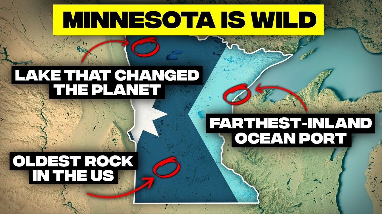
A glacial lake dwarfed all modern Great Lakes.
After the last ice age, Glacial Lake Agassiz formed, covering most of Minnesota, North Dakota, and Manitoba. At its peak, it spanned about 170,000 square miles, larger than all five modern Great Lakes combined, dramatically reshaping the continent upon its drainage.
Touch the United States' oldest exposed rock.
Near Morton, Minnesota, you can stand on 3.5 billion-year-old rock, known as Morton Gneiss. This ancient formation, older than multicellular life or oxygen-rich air, formed under immense heat and pressure deep within Earth's early crust, and has been quarried for global architecture.
A meteor crater hides beneath the Twin Cities suburbs.
In 2021, scientists confirmed a 2.5 mile wide meteor crater buried beneath Inver Grove Heights, south of St. Paul. Formed approximately 490 million years ago, this impact site was later hidden by hundreds of feet of glacial sediment, making it an unseen cosmic scar.
An entire region was mysteriously skipped by glaciers.
Southeastern Minnesota's Driftless Area looks distinct from the rest of the state because glaciers bypassed it during the last ice age. This region features steep limestone bluffs, narrow river valleys, caves, and sinkholes, creating a rugged landscape more akin to Appalachia than the typical Midwest.
A billion-year-old cliff defies erosion.
Palisade Head, a 335-foot volcanic cliff, rises directly from Lake Superior's shoreline, having withstood erosion for over 1.1 billion years. Formed during the Mid-Continent Rift, it remains a prominent geological feature and a popular rock-climbing destination.
Minnesota's "mountains" are actually tilted lava.
The Sawtooth Mountains, while impressive, are not true mountains but ancient lava flows tilted upward during the collapse of the Mid-Continent Rift over a billion years ago. Rising 1,500 to 1,800 feet from Lake Superior, they create dramatic relief along the North Shore.
The state sits on North America's ancient core.
Much of Minnesota rests on the Canadian Shield, the ancient granite core of North America. In the Arrowhead region, bedrock over 2.7 billion years old reaches the surface, extending 35 miles deep, explaining the state's geological stability and rich mineral deposits.
A massive glacial lake changed the entire planet.
Glacial Lake Agassiz, covering vast areas of Minnesota and Canada, catastrophically drained around 8,200 years ago. This release of freshwater disrupted Atlantic Ocean circulation, triggering a global cooling event and raising sea levels worldwide, making it a true world-altering geological event.
When you touch this rock, you're touching a fragment of Earth's original crust, older than multicellular life, older than plants, older than oxygen-rich air itself.
Extreme Conditions and Icy Spectacles
A lake once turned into a slow-motion tsunami.
In 2013, strong winds on Mille Lacs Lake pushed thick ice inland, piling frozen slabs 30 feet high against homes, a phenomenon known as an ice shove. This slow-motion "tsunami" of ice, described as sounding like constant gunfire, can destroy homes in minutes.
A 175-degree temperature whiplash is common.
Minnesota experiences one of the biggest temperature ranges on Earth outside polar regions, with a record high of 115°F and a record low of -60°F, a staggering 175-degree swing. This volatility is due to its continental location, far from moderating oceans.
A foot of rain can fall in a single day.
In August 2007, the town of Hokah in southeastern Minnesota received an astonishing 15.1 inches of rain in 24 hours due to a training thunderstorm. This single-day deluge led to widespread flooding, surging rivers, and disaster declarations in seven counties.
Three feet of snow once fell in one day.
On January 7, 1994, northeastern Minnesota experienced one of its most intense snow events, with weather stations near Finland recording 36 inches of snowfall in 24 hours. This overnight accumulation buried cars and caused roofs to collapse under the immense weight.
Lake Superior forms spectacular ice volcanoes.
In winter, Lake Superior's waves can create "ice volcanoes" along its frozen shoreline. Water shoots through cracks in ice shelves, freezing midair to build hollow cones over 25 feet tall, resembling frozen geysers or alien towers along the beach.
Lake Superior emits dramatic steaming sea smoke.
On frigid winter mornings, Lake Superior appears to boil, emitting thick white fog known as sea smoke or Arctic steam fog. This occurs when extremely cold air, sometimes below -20°F, passes over the relatively warm lake water, causing rapid evaporation and condensation.
The ground literally explodes from frost quakes.
Minnesotans are familiar with frost quakes, sudden loud booms that rattle windows. These cryoseisms occur when water in soil freezes rapidly, expanding and fracturing rock underground, releasing pressure violently with a loud crack, especially during extreme cold snaps.
A frozen waterfall allows you to walk inside it.
Minnehaha Falls, a popular Minneapolis landmark, transforms in winter into a massive blue-white ice curtain. The freezing process often hollows out a cavity behind the 53-foot falling ice, allowing visitors to walk inside what is normally rushing water, experiencing a temporary cathedral of ice.
Lake Superior remarkably resists freezing solid.
Despite brutal winters, Lake Superior rarely freezes completely due to its immense depth, constant wave motion, and stored heat. Typical winters see 40 to 95% ice cover, with some years dropping as low as 3%, a testament to its thermal power.
International Falls holds the title of "Nation's Icebox."
International Falls, situated on the Canadian border, has earned its trademarked nickname due to its extreme cold. January lows average around -7°F, and in 1909, the temperature plummeted to -55°F, making it ground zero for Arctic air spilling into the US.
Landscapes of Contrast
Thirteen miles of cave lie beneath quiet farmland.
Southeastern Minnesota conceals Mystery Cave, the state's longest cave system, stretching over 13 miles beneath seemingly tranquil farmland. Discovered in 1937, its limestone bedrock was carved by groundwater over tens of thousands of years, maintaining a constant 48°F temperature.

A million acres offer pure, unadulterated darkness.
In 2020, the Boundary Waters Canoe Area Wilderness became the largest international dark sky sanctuary on Earth, covering 1.1 million acres with virtually no light pollution. On moonless nights, the Milky Way casts shadows, and the Northern Lights reflect perfectly off still waters.
Minnesota harbors a surprising hidden desert.
Central Minnesota's Anoka Sand Plain, the leftover bed of a massive glacial river, creates a dry prairie ecosystem resembling the Southwest. This unique habitat supports jackpine, oak savannah, and even prickly pear cactus, along with over 130 rare plant and animal species.
Three major biomes dramatically collide in one state.
Minnesota sits at a rare ecological crossroads where three major North American biomes converge: tallgrass prairies from the west, the Canadian boreal forest from the north, and eastern temperate forests. This unique collision fosters exceptional biodiversity, with species rarely coexisting elsewhere thriving here.
Striped bogs are visible from the sky.
Northern Minnesota's peatlands, like the Red Lake Peatland, appear from above as long, cream-colored stripes alternating with dark channels. These "patterned bogs" form as peat moss organizes into ridges and wet troughs over centuries, creating a unique, carbon-locking ecosystem up to 15 feet deep.
Witness Northern Lights without traveling to Alaska.
Thanks to its northern latitude, dark skies, and proximity to the auroral oval, Northern Minnesota is one of the best places in the lower 48 to observe the Northern Lights. During strong solar storms, green curtains and red pillars can cover the sky, often reflecting beautifully off still lakes.
Highest and lowest points are just 15 miles apart.
Minnesota's Arrowhead region boasts a compressed elevation contrast: Eagle Mountain, the state's highest point at 2,301 feet, lies just 15 miles from Lake Superior, its lowest point at 601 feet above sea level. This sharp relief is unusual for the Midwest.
Human Footprints and Unique Borders
The Red River flows "uphill," causing major floods.
Minnesota's Red River of the North flows northward across the extremely flat floor of ancient Lake Agassiz, with a slope of just 1 to 2 inches per mile. When southern snow melts while the northern river is still frozen, water piles up and causes widespread flooding in cities like Fargo and Grand Forks.
An 8-mile long man-made canyon exists.
On Minnesota's Iron Range, the Hull-Rust-Mahoning Open Pit Mine near Hibbing stretches an astonishing 8 miles long, 3.5 miles wide, and 600 feet deep. So vast was its expansion that in 1919, the entire town of Hibbing had to be moved to avoid being swallowed by the mine.
A national park is largely inaccessible by road.
Voyageurs National Park is unique because roads are scarce. About 40% of its 218,000 acres is open water, a maze of lakes and islands along the Canadian border. Exploration is primarily by boat or canoe, though in winter, a temporary ice road forms, turning frozen water into a highway.
The deepest inland lake is actually a flooded mine.
Minnesota's deepest inland lake, Portsmouth Mine Pit Lake near Crosby, was created by humans. This former open-pit iron mine, closed in 1962, flooded to a depth of roughly 450 feet, now a clear-water haven for scuba divers exploring submerged mining equipment.
Sacred stone lies beneath the prairie.
In southwestern Minnesota, the Pipestone Quarries are a critical geological and cultural site. Here, a narrow seam of soft red catlinite, or pipestone, is quarried by indigenous nations for ceremonial pipes, a tradition where geology, spirituality, and history profoundly intersect.
The world's farthest inland ocean port is in Duluth.
Duluth, Minnesota, is the farthest inland port on Earth accessible to oceangoing ships, located roughly 2,300 miles from the Atlantic via the Great Lakes and St. Lawrence Seaway. Massive cargo ships from Europe navigate here, making it a vital global trade hub.
Science operates half a mile underground.
The Soudan Underground Laboratory, located 2,330 feet below ground in a former iron mine, hosts sensitive particle physics experiments. The thick rock shields detectors from cosmic radiation, creating ideal conditions to study neutrinos and search for dark matter, turning geology into a scientific frontier.
America's northernmost town exists due to a mapping error.
Thanks to an 18th-century mapping error, Minnesota's Northwest Angle is the only place in the lower 48 states north of the 49th parallel. Angle Inlet, its primary settlement of about 120 residents, is the northernmost town in the contiguous US, accessible mostly through Canada.
The state's geographic balance point is surprisingly quiet.
Minnesota's geographic center, the theoretical point where the state would balance if flattened, lies southwest of Brainerd in Crow Wing County. Unlike St. Paul's historical, disproven claim to be North America's center, the true spot is marked by trees, dirt, and quiet solitude.
Buffalo Ridge provides Minnesota's wind power backbone.
Buffalo Ridge in southwestern Minnesota's Coteau des Prairies is one of the best wind energy locations in the country. Its elevated terrain and steady airflow make it ideal for turbines, which now power hundreds of thousands of homes, transforming a historical bison migration route into a hub for renewable energy.
From ancient geological near-misses to modern engineering marvels, Minnesota's geography offers a masterclass in the unexpected. It reminds us that the world, even in its seemingly quiet corners, is a place of constant flux, shaped by forces spanning billions of years and moments of extreme weather. The map, it turns out, is merely a suggestion, and the true story of a place is often stranger, wilder, and far more fascinating than any textbook could convey.


