West Virginia, often imagined as a uniform tapestry of rolling hills and coal towns, is in fact a geographical anomaly, a land where the ordinary gives way to the truly wild. Its entire expanse is folded within one mountain system, a unique distinction in the United States. From rivers older than the mountains they carve to valleys that claim the East's coldest temperatures, the Mountain State is a constant plot twist. It's a place where ancient geology dictates modern life, where the land itself seems to rebel against convention, creating landscapes that are both breathtaking and bewildering.
The Mountain's Unyielding Grip
West Virginia: The only state made entirely of mountains.
West Virginia isn't just a mountainous state, it's the only one where every square mile lies within a single mountain system. The entire state sits inside the Appalachian Mountains, with no coastal plains or major flatlands. This constant elevation gives West Virginia the highest average elevation of any state east of the Mississippi River.
Highest average elevation east of the Mississippi.
West Virginia's land is defined by elevation, with an average of approximately 1,500 feet, higher than any other state east of the Mississippi River. While its lowest point at Harpers Ferry is 247 feet, the terrain rises dramatically to 4,863 feet at Spruce Knob, the state's highest peak.
Spruce Knob sits on the Eastern Continental Divide.
Spruce Knob, West Virginia's highest point, sits along the Eastern Continental Divide. Water falling on one side drains westward to the Gulf of Mexico via the Ohio and Mississippi rivers. Rain falling a short distance away flows eastward through the Potomac River to the Chesapeake Bay and the Atlantic Ocean.
Elevation defines the entire Mountain State.
West Virginia's land is shaped almost entirely by elevation, with an average of roughly 1,500 feet, the highest of any state east of the Mississippi River. Its lowest point at Harpers Ferry still sits above 240 feet, while Spruce Knob rises to 4,863 feet. These changes create intense local climates and influence everything.
A state almost entirely devoid of flat lands.
West Virginia's geography is almost entirely defined by mountains and valleys, lacking common landforms like coastal plains or major prairies. During the last ice age, massive glaciers stopped just short of the region, leaving its terrain untouched by the flattening forces that shaped most of the Midwest. Long stretches of level ground are relatively rare.
The entire state sits inside the Appalachian Mountains, with no coastal plains or major flatlands.
Rivers That Defy Expectation
The Ohio River legally belongs to West Virginia.
Most rivers forming state boundaries are split down the middle, but the Ohio River is different. Along West Virginia's western border, the entire river legally belongs to West Virginia, all the way to the Ohio shoreline. This unusual arrangement dates back to colonial Virginia's claims, transferring to West Virginia when it became a state in 1863.
The New River: A geologically ancient waterway.
Despite its name, the New River is widely considered one of the oldest rivers on Earth. Geologists estimate parts of its system may be more than 300 million years old, predating the Appalachian Mountains' current form. It maintained its path as land uplifted, carving the New River Gorge and flowing northward, an odd direction for the region.
A state with almost no natural lakes.
Despite numerous rivers and streams, West Virginia has almost no natural lakes. The only widely recognized natural lake is Trout Pond, a small sinkhole lake. The rugged Appalachian terrain drains water quickly, preventing large natural basins from forming, and glaciers never reached this far south to carve them.
The Lost River vanishes underground.
In Hardy County, the Lost River truly lives up to its name. Flowing through the Capon Valley, the river suddenly disappears underground at a limestone formation known as "The Sinks." It travels unseen for roughly two miles under Sandy Ridge, reappearing as the Capon River.
Blackwater Canyon's 1,000 foot deep amber gorge.
Blackwater Canyon cuts a 1,000-foot deep gorge through the Allegheny Plateau. Its river is famous for its deep amber tint, created by tannins released from fallen leaves in hemlock forests upstream. This natural compound stains the water as it rushes through rapids and over Blackwater Falls, dropping nearly 60 feet.
One of America's most stream-dense environments.
West Virginia is one of the most water-threaded environments in the United States, boasting over 30,000 miles of streams and rivers. This outrageous concentration for its size stems from the rugged Appalachian terrain, where steep ridges funnel rainfall into countless creeks and runs.
Smokehole Canyon's hidden, isolated gorge.
Along the South Branch of the Potomac River lies Smokehole Canyon, a rugged 20-mile stretch of limestone cliffs and winding water. Canyon walls rise hundreds of feet, creating narrow passages where sunlight reaches the water for only minutes each day. Its isolation preserved one of Appalachia's most scenic corridors.
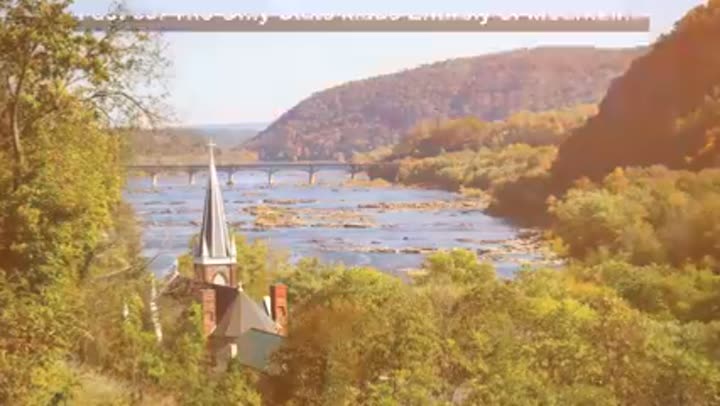
The Potomac River's mountain source.
The Potomac River, famous for flowing through Washington DC, originates far from the capital in West Virginia's mountains. Its northern branch begins near the Fairfax Stone, a 1746 boundary marker. From this quiet spring, the river journeys nearly 400 miles before reaching the Chesapeake Bay.
The Trough: Potomac's hidden water gap.
Deep in eastern West Virginia's mountains, The Trough is a narrow gorge where the South Branch of the Potomac River cuts through Appalachian ridges for nearly six miles. This "superimposed drainage" means the river established its path before the mountains fully rose, eroding downward as the land uplifted.
Greenbrier River: A long, free-flowing waterway.
The Greenbrier River is one of the longest free-flowing rivers in the eastern United States, stretching about 176 miles through southeastern West Virginia. It remains undammed along its main channel, allowing natural seasonal rhythms. Its route is paralleled by the Greenbrier River Trail, a scenic rail trail.
Gauley River: World-class whitewater rapids.
The Gauley River is one of the most famous whitewater rivers in the United States. Over roughly 25 miles, it drops more than 650 feet through a narrow sandstone gorge, creating powerful rapids. Each fall, controlled water releases from Summersville Dam create "Gauley season," transforming it into a world-class run.
Cheat River Canyon: A remote, wild gorge.
The Cheat River Canyon in northern West Virginia is one of Appalachia's most remote and intense gorges. In places, canyon walls rise more than 1,000 feet above the river, forming a rugged corridor. Its steep terrain and limited road access preserved a large wilderness area, rare in the eastern United States.
The ghost of the ancient Teays River.
Before the modern Ohio River, a massive prehistoric waterway called the Teays River flowed across what is now West Virginia, draining a huge portion of the eastern United States. Advancing glaciers during the ice age blocked its northern outlets, creating enormous lakes and reshaping the region's drainage system. Its legacy remains in unusually broad valleys.
Potomac's South Branch cuts through mountains.
The South Branch of the Potomac River cuts through some of Appalachia's most rugged terrain. In multiple places, the river slices directly through mountain ridges, forming narrow gaps and canyons like Smokehole Canyon and The Trough. These are examples of rivers maintaining their courses as surrounding land slowly uplifted.
Beneath the Surface: Karst and Caves
A land filled with over 4,000 documented caves.
Under West Virginia's mountains lies a massive underground world shaped by limestone geology. The state contains more than 4,000 documented caves, formed over millions of years as acidic groundwater dissolved soluble rock. Some systems, like Friars Hole, extend for dozens of miles.
Historic caves mined for Civil War gunpowder.
Several West Virginia cave systems hold significant historical importance. Organ Cave, one of the largest, with 45 miles of mapped passages, was heavily mined during the Civil War for saltpeter, a key gunpowder ingredient. Friars Hole, over 50 miles long, is among North America's longest.
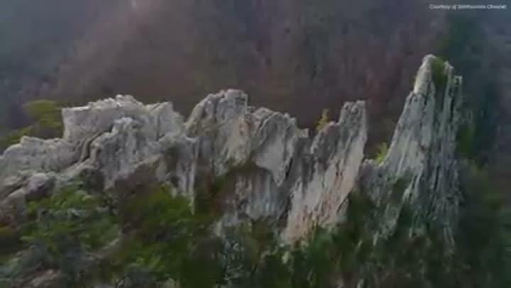
Beartown State Park's maze of sandstone towers.
High in the eastern mountains, Beartown State Park features an unreal environment of towering sandstone formations. Millions of years of erosion carved narrow passageways through massive rock columns, creating natural corridors resembling a stone city. Water and frost slowly widened fractures, producing slot-like passages.
The Allegheny Front, Appalachia's natural weather wall.
The Allegheny Front is a towering escarpment running through eastern West Virginia, rising 1,500 to nearly 2,000 feet. It forms a sharp boundary between the high Allegheny Plateau to the west and lower valleys to the east. Moist air is forced upward along the front, producing heavy snowfall and rainfall on the plateau side.
Germany Valley's hidden karst environment.
Tucked deep in the Allegheny Mountains, Germany Valley is a broad limestone basin surrounded by 4,000-foot peaks. It was shaped by karst geology, where acidic water dissolves limestone, creating sinkholes, underground streams, and long cave systems. Its natural barriers make it feel unusually enclosed.
Capon Mountain: A 50-mile natural wall.
Stretching roughly 50 miles across West Virginia's Eastern Panhandle, Capon Mountain is a prominent ridge in the Appalachian Ridge and Valley region. It is a classic hogback formation, built from durable sandstone that resisted erosion. The mountain forms a long, straight wall rising over 2,000 feet above nearby valleys.
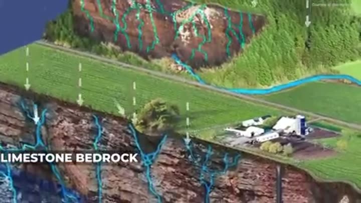
A landscape profoundly shaped by karst geology.
Much of eastern West Virginia sits atop limestone bedrock, which slowly dissolves when exposed to acidic rainwater. Over millions of years, this created karst terrain filled with caves, sinkholes, and disappearing rivers. Water often travels through hidden channels, sometimes reappearing miles away as powerful springs, making the land hydrologically complex.
North Fork Mountain's enduring quartzite spine.
North Fork Mountain forms one of the most absurd ridges in the Appalachian Mountains. Extending for about 26 miles, it's built from extremely resistant Tuscarora quartzite, a rock layer that survived erosion for hundreds of millions of years. Its crest forms a narrow, elevated spine rising nearly 4,000 feet.
Seneca Rocks: A vertical slice of ancient Earth.
Seneca Rocks, a towering fin of stone rising nearly 900 feet above the North Fork Valley, is a recognizable landmark. Composed of Tuscarora quartzite, this hard rock originated as beach sand roughly 440 million years ago. Tectonic forces later folded these layers upright, creating its almost vertical stance.
Its steep terrain and limited road access preserved a large wilderness area, rare in the eastern United States.
Ecological Time Capsules and Wildlands
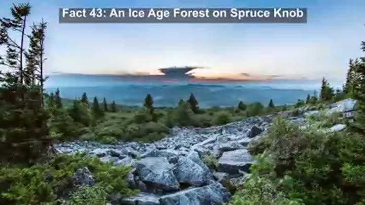
Spruce Knob hosts a relict ice age forest.
At 4,863 feet, Spruce Knob hosts thick red spruce forests resembling ecosystems found hundreds of miles north in Canada. These are relict ecosystems, remnants from the last ice age that survived by clinging to high elevations. Harsh winds cause "flagging," where trees grow unevenly, often losing branches on the windward side.
One of America's most heavily forested states.
West Virginia is essentially a forest, with roughly 78 to 79 percent of the state covered in trees. This is largely due to the steep, rugged terrain, which makes large-scale farming and urban development difficult. As industries declined and farmland was abandoned in the 20th century, forests reclaimed the land.
The East's densest black bear population thrives.
West Virginia now supports one of the largest black bear populations east of the Mississippi River. From fewer than 500 bears in the early 1970s, estimates now place the population between 12,000 to 14,000, occupying all 55 counties. This recovery is attributed to improved habitat and careful management policies.
Dolly Sods: A piece of Canada in West Virginia.
Dolly Sods Wilderness is a windswept plateau in the Allegheny Mountains that feels more like northern Canada than the Mid-Atlantic. Sitting between 2,500 and 4,700 feet, it hosts boreal ecosystems like sphagnum bogs and stunted red spruce. Constant winds twist most trees sideways, creating "flagged" forests.
Cranberry Glades: The southernmost Arctic bog.
Cranberry Glades in Monongahela National Forest is a 750-acre complex of bogs resembling Arctic tundra. Cold air pooling creates a natural frost pocket, with freezing temperatures even in summer. Its acidic, nutrient-poor environment supports carnivorous plants like pitcher plants and sundews, species typically found much farther north.
Monongahela Forest: A vast mountain ecosystem.
Covering roughly 919,000 acres, the Monongahela National Forest is one of the largest protected areas in the eastern United States. Established in 1920 after widespread logging, it has regenerated into a huge mountain ecosystem. Its diverse headwaters drain into both the Ohio River system and the Chesapeake Bay watershed.
Gaudineer Knob: A forest logging missed.
High in the Allegheny Mountains, Gaudineer Knob holds one of the last surviving pockets of original red spruce forest in West Virginia. This 140-acre patch of old-growth trees was reportedly overlooked during early timber surveys. Some spruce here are estimated to be over 300 years old, preserving a rare glimpse of pristine Appalachia.
Roaring Plains, a high-altitude "sky island."
Roaring Plains Wilderness, high in the Allegheny Mountains, is one of the highest plateaus in the eastern United States. Sitting around 4,000 to 4,700 feet above sea level, this windswept tableland experiences harsh conditions akin to climates hundreds of miles north. Scientists call such isolated, high-elevation ecosystems "sky islands."
Boundaries, Bridges, and the Quiet Air
A state shaped by Civil War and strategic railroads.
West Virginia's unusual shape is a product of Civil War politics, geography, and strategic railroads. The state contains two narrow panhandles stretching in opposite directions, creating one of the most irregular outlines in the United States. The Eastern Panhandle controlled key sections of the Baltimore and Ohio Railroad, a critical Union supply route.
America's radio quiet zone protects a giant telescope.
Deep in Pocahontas County lies Green Bank, the center of the National Radio Quiet Zone, a 13,000 square mile region where most wireless signals are prohibited. This zone protects the Green Bank Telescope, the world's largest fully steerable radio telescope, which detects faint signals from distant galaxies.
Interstate bridge that soars 700 feet above a valley.
The Phil G. McDonald Memorial Bridge carries Interstate 64 high above Glade Creek, with its deck rising roughly 700 feet above the valley floor. This made it one of the tallest steel deck truss bridges ever built, and briefly the highest point on the entire US interstate highway system when it opened in 1977.
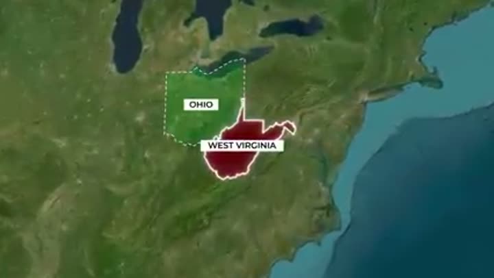
A small state bordering five different neighbors.
Despite its relatively small size, West Virginia borders five states: Ohio, Pennsylvania, Maryland, Virginia, and Kentucky. Many boundaries follow natural features, like the Ohio River in the west and the Potomac River outlining sections of the north and east. These waterways and rugged terrain shaped its unusual outline during the Civil War.
The New River Gorge Bridge, an engineering marvel.
The New River Gorge Bridge spans approximately 1,700 feet across the gorge and stands about 876 feet above the river. When it opened in 1977, it was the longest single-arch steel bridge in the world for over two decades. Its distinctive weathering steel forms a protective rust coating.
Wheeling Island, a city on the Ohio River.
Wheeling Island is one of the most unusual communities along the Ohio River, stretching approximately 1.75 miles long. It contains entire neighborhoods, schools, and businesses within the city of Wheeling. West Virginia legally controls the Ohio River all the way to the low water mark on the Ohio shoreline.
The "West" that isn't furthest west.
Despite its name, West Virginia is not actually further west than the state of Virginia. Its irregular historical county boundaries mean Virginia's southwestern corner extends farther west toward the Cumberland Gap than West Virginia's westernmost point. This results in a geographic irony: the state called West Virginia doesn't extend as far west as the state it separated from.
The Highland Scenic Highway, a high-altitude drive.
The Highland Scenic Highway is one of the wildest drives in the Appalachian Mountains. This 43-mile route through the Monongahela National Forest climbs above 4,000 feet in elevation, making it one of the highest major highways in the eastern United States. Sections close during colder months due to extreme winter conditions.
Where Weather Writes the Landscape
Canaan Valley: The East's coldest inhabited place.
High in the Allegheny Mountains, Canaan Valley is one of the coldest inhabited places in the eastern United States. Sitting around 4,400 feet above sea level, this wide basin traps cold air, leading to over 130 inches of snowfall annually. Frost has been recorded in every month of the year, even midsummer.
Appalachian Highlands: A lightning hotspot.
West Virginia's rugged mountains create some of the most active thunderstorm zones in the eastern United States. Warm, moist air from the Gulf collides with cooler air over the Allegheny Highlands, forcing it upward through orographic lifting. This process quickly builds powerful storm clouds that frequently produce lightning.
Mountain geography amplifies flash floods.
West Virginia's steep terrain intensely amplifies heavy rainfall. During major storms, water rushing down narrow valleys and hollows quickly funnels into rivers, producing rapid, severe flooding. In June 2016, over 10 inches of rain fell in hours, causing historic flooding in several river basins.
Extreme weather contrasts across short distances.
West Virginia's steep elevation changes create outrageous weather contrasts. High mountain areas experience heavy snowfall (60-100 inches) and cool summers, while lower river valleys can see intense summer heat. The state's all-time high temperature reached 112 degrees Fahrenheit during the 1936 heatwave, driven by altitude differences.
Geographic Cores and Lost Places
Pendleton County, the Mountain State's core.
If West Virginia is defined by mountains, Pendleton County sits at its heart. This remote county concentrates intense landscapes: Spruce Knob (the state's highest peak), Seneca Rocks, Smokehole Canyon, and Germany Valley. Despite this extraordinary geography, it remains one of the least densely populated counties east of the Mississippi.
The town submerged under Summersville Lake.
Under the clear blue waters of Summersville Lake, West Virginia's largest lake, lie the remains of a former community. When Summersville Dam was completed in the 1960s, the reservoir flooded the small town of Gad, along with farms and buildings. Traces of the old town still sit under the lake, sometimes visible to divers.
From its geological anomalies to its ecological paradoxes, West Virginia is a testament to geography's power to shape destiny and defy expectations. It reminds us that the world is far stranger and more complex than any textbook might suggest, a place where the ancient past is visible in every river bend and mountain peak. These 50 facts are just a glimpse into the plot twists written into the very bedrock of the Mountain State, inviting us to look closer and discover the wild, hidden wonders that make our planet so endlessly fascinating.


