Arkansas, often pictured as a quiet tableau of rolling hills and dense forests, harbors a geographical narrative far more dramatic than its serene reputation suggests. This is a landscape where ancient volcanic eruptions once scattered diamonds, where rivers mysteriously shift state boundaries, and where subterranean forces sculpt vast cave systems and unleash powerful quakes. Beneath its tranquil surface, the Natural State reveals an astonishing array of geological anomalies and ecological wonders, challenging every preconceived notion. Prepare for a journey through a land defined by surprising extremes and hidden depths, a place where the earth itself tells stories stranger than fiction.
Deep Earth's Riches and Mineral Veins
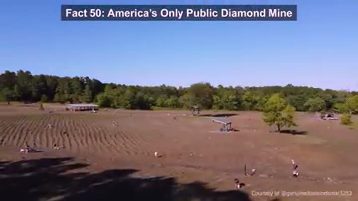
America's only public diamond mine, dig and keep.
Crater of Diamonds State Park offers a unique opportunity: find a diamond, keep a diamond. Roughly 100 million years ago, a volcanic eruption brought diamonds to the surface, scattering them across a 37-acre field. Over 75,000 diamonds have been recovered here, including the 40.23 carat "Uncle Sam," the largest ever found in the United States. Visitors still find one or two diamonds daily.
Soak in ancient rainwater at Hot Springs National Park.
The thermal waters of Hot Springs National Park are not ordinary groundwater. Scientists estimate the rain falling today takes approximately 4,400 years to complete its underground journey, heating naturally to about 143 degrees Fahrenheit. More than a million gallons rise daily, making it one of America's earliest spa destinations. This is the only US national park located fully inside a city.
Magnet Cove: where compasses behave erratically.
Magnet Cove, a 5-mile wide volcanic complex in central Arkansas, contains unusually high concentrations of magnetite. This mineral causes compass readings to act erratically in certain spots. Geologists consider it one of North America's most mineralogically diverse small areas, with over 100 different mineral species identified, offering a rare window into deep magmatic processes.
Four-ton quartz giant unearthed in Arkansas.
Arkansas is a premier quartz producing region. In 2016, miners near Jesseville uncovered the "Burns Quartz," a specimen 7 feet tall and weighing roughly 8,000 pounds. Its surface was covered with thousands of clear crystals, making it one of the largest intact quartz clusters recorded in the state. Arkansas quartz was strategically important for radio oscillators during World War II.
Arkansas bauxite fueled Allied World War II aircraft.
Central Arkansas sits on one of the largest bauxite deposits in the United States, the primary ore for aluminum. During World War II, this geology was strategically critical. At its 1943 peak, mines around Bauxite produced over 6 million tons of ore, supplying the overwhelming majority of aluminum for American aircraft. This supply was crucial for the Allied air fleet.
Novaculite: Arkansas's world-renowned sharpening stone.
Arkansas became globally known for novaculite, an exceptionally dense, fine-grained silica rock ideal for sharpening blades. Formed 300 to 350 million years ago, quarries near Hot Springs produced wet stones exported worldwide by the early 1800s. "Arkansas stones" became industry standards, and the US military even stockpiled them during World War II. It remains historically important.
Southern Arkansas: a global bromine powerhouse.
Southern Arkansas contains one of the richest bromine-bearing brine formations on the planet, the Smackover Formation. Deep saltwater reservoirs here are unusually concentrated in bromine. Today, operations in Union and Colombia counties extract significant volumes used in flame retardants, pharmaceuticals, and industrial chemicals. For decades, Arkansas production ranked the US among the world's leading bromine suppliers, largely out of public view.
Coal under Arkansas River Valley fueled industry.
The Arkansas River Valley harbors one of the state's most historically important coal regions. The Arkansas coal field, spanning roughly 33 miles wide and 60 miles long, centered production in Sebastian County. From 1880 to 1976, this county alone produced over half of Arkansas's total coal output. This low-sulfur coal, formed 300 million years ago, fueled locomotives and steam engines during the state's industrial peak.
Arkansas quartz became strategically important during World War II because of its purity for radio oscillators before synthetic quartz was widely available.
Lands Forged by Forces and Time
Crowley's Ridge: an anomalous highland in flat delta.
The flat Arkansas Delta is interrupted by Crowley's Ridge, a narrow highland rising up to 250 feet and stretching 150 miles. Geologists believe ancient Mississippi and Ohio River courses isolated this land strip, later buried under thick windblown loess during the ice age. The result is bizarre: hardwood forests typical of the Appalachians sitting amidst cotton country, one of the strangest topographic outliers in the central United States.
Ouachita Mountains: an east-west oriented range.
Unlike most North American ranges, the Ouachita Mountains run east to west across Arkansas and Oklahoma. Formed over 300 million years ago during continental collisions, this unusual alignment creates absurd environmental differences. South-facing slopes bake in sun, supporting pine forests, while north-facing slopes stay cooler and wetter. Same mountains, completely different ecosystems based on direction.
Mississippi River shifted, stranding Arkansas land.
In 1876, the Mississippi River changed course near Horseshoe Bend, effectively rearranging the map. It cut a new channel, abandoning an old loop, leaving a slice of Arkansas physically stranded on the Mississippi side. Land previously attached to Arkansas was now separated by the river. The legal state line was fixed along the old path, but the geography still looks wrong on a map today.
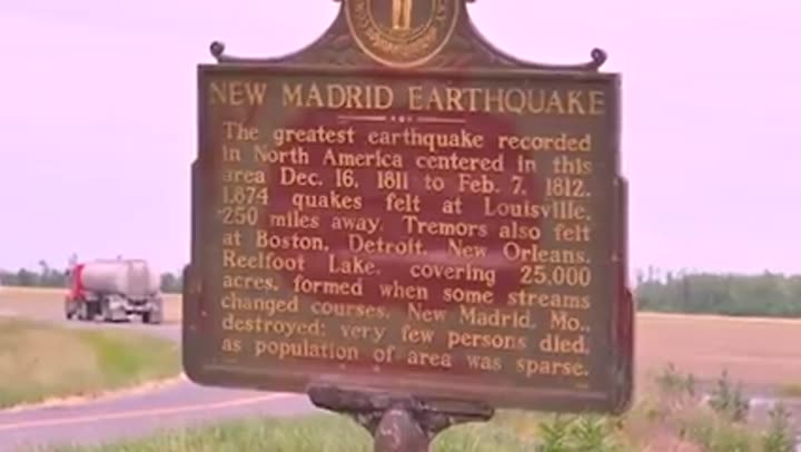
New Madrid quakes created Arkansas's sunken lands.
The powerful 1811-1812 New Madrid earthquake sequence struck northeast Arkansas. Some shocks estimated near magnitude 7 or higher caused ground liquefaction, sinking entire forests between 6 and 15 feet. This created the "Sunken Lands," roughly 30 miles of woodland that dropped below the water table, turning into swamp. Sand blows and surface scars still mark the land today.
Arkansas experiences extreme weather temperature swings.
Arkansas has recorded one of the widest temperature swings in the US. The all-time high reached 120 degrees Fahrenheit in 1936, while the record low dropped to -29 degrees Fahrenheit in 1905, a 149-degree historical spread. The state's location, a collision zone between Gulf moisture and continental cold air, explains this volatility. Extreme heat, winter outbreaks, and severe storms can all occur within the same season.
Paragould meteorite: a massive 1930 space rock fall.
On February 17, 1930, a bright fireball streaked across the Arkansas sky near Paragould. The object fragmented, and farmers recovered multiple meteorite pieces. The largest single mass weighed about 820 pounds, with total recovered material over 1,400 pounds. This made it one of the largest documented meteorite falls in US history. Fragments are now in museum collections, providing samples of early planetary material.
Ancient Arkansas once lay beneath warm shallow seas.
Long before the Ozarks or Ouachitas, much of what is now Arkansas sat under a warm shallow sea. Roughly 300 to 350 million years ago, marine environments covered large parts of the region, leaving thick deposits of limestone and other sedimentary rock. Drilling and quarries regularly expose fossil-rich layers containing ancient corals, crinoids, and shark remains. Much of Arkansas's geology formed on this ancient seafloor.
New Madrid quakes shook half a continent in 1811-12.
Between December 1811 and February 1812, a series of powerful earthquakes struck the New Madrid seismic zone near the Arkansas-Missouri border. These rank among the strongest recorded in the continental US. Contemporary accounts describe the Mississippi River briefly reversing flow and widespread ground liquefaction. Shaking was felt over an enormous area, reportedly ringing church bells hundreds of miles away. The fault system remains active today.
Gravity Hills: where cars appear to roll uphill.
Several Arkansas locations are known as Gravity Hills, where cars in neutral appear to roll uphill. One well-known example is near Helena along Highway 49. This phenomenon is a well-documented optical illusion. The surrounding land creates a false horizon, tricking the eye into misjudging the road's true slope. In reality, the vehicle is still rolling downhill, a popular roadside curiosity.
Ozark booms: unexplained cannon-like sounds persist.
For over a century, residents in parts of the Boston Mountains have reported sudden, cannon-like booms with no obvious source. Often called "Ozark howlers" or "mountain booms," these sounds sometimes occur on clear days with no thunderstorms. Witnesses describe deep, low rumbles that seem to echo through the hills. Scientists propose small seismic events or pressurized gas release, but no single explanation fully accounts for every report. The Ozarks remain a persistent hotspot for this unusual acoustic phenomenon.
In Arkansas, extreme heat, winter outbreaks, and severe storms can all happen within the same season.
Water's Relentless Sculptures and Flows
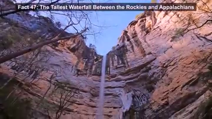
Hemmed-in Hollow Falls: tallest waterfall in a vast region.
Hidden deep within the Buffalo National River Wilderness, Hemmed-in Hollow Falls drops 209 feet in a single plunge. This makes it the tallest waterfall between the Rocky Mountains and the Appalachians, taller than the main drop of Niagara Falls. After heavy rains, it transforms into a roaring ribbon of water. The challenging 1,400-foot descent hike ensures the area remains largely untouched.
Bayou Bartholomew: the world's longest bayou.
The world's longest bayou, Bayou Bartholomew, doesn't start in Louisiana, but in Arkansas. It runs roughly 359 miles from central Arkansas into northern Louisiana. This highly biodiverse system formed thousands of years ago when the Arkansas River abandoned an old channel. Today, it supports over 100 species of fish and massive cypress-tupelo wetlands, a critical ecological waterway.
Buffalo River: America's first national river.
The Buffalo River holds a unique distinction: in 1972, it became America's first national river, preserved to remain free-flowing and undammed. It runs about 135 miles through northern Arkansas, cutting under limestone bluffs over 500 feet high. A 1960s dam project was stopped by a national conservation campaign. Today, it remains one of the few large, fully undammed rivers in the lower 48.
Mammoth Spring: millions of gallons flow hourly.
Under the Ozarks, Mammoth Spring discharges an outrageous 9 million gallons every hour. This flow fills a 10-acre spring lake before forming the Spring River, supplying about half its total volume. The water maintains a constant 58 degrees Fahrenheit year-round, often creating visible mist. Ranked among the largest springs in the US, its steady flow once powered mills and early hydroelectric plants.
Red River's Great Raft: a 170-mile log jam.
For centuries, the Red River was blocked by the "Great Raft," a massive tangle of fallen trees and debris stretching roughly 170 miles. This obstruction created huge swamps and made upstream navigation nearly impossible. In the 1830s, Captain Henry Shreve began clearing it with snagboats. The raft repeatedly reformed until engineers finally eliminated the remaining sections in 1873, ending one of the continent's most persistent river blockages.
Red River gets its name from iron-rich sediments.
The Red River earns its name from the geology it flows through. As it cuts across Permian-age red beds, sedimentary rocks rich in iron oxide, it picks up fine reddish particles. These tint the water a muddy red-brown, especially after heavy rains. This natural coloration, observed since early explorations, originates from ancient oxidized soils and sandstones deposited millions of years ago.
Lake Chicot's clarity altered by 1927 Mississippi flood.
Lake Chicot, North America's largest oxbow lake, was once known for clear water. That changed drastically after the Great Mississippi Flood of 1927. A levee failure allowed floodwaters to pour into the lake, carrying massive amounts of suspended sediment. This sudden influx of silt permanently altered the lake's water clarity and sediment balance. Today, it remains a popular fishing destination.
Arkansas's cold-water dams created trophy trout fishing.
Arkansas isn't typically known for trophy trout, but cold-water dam releases transformed its rivers. In 1992, the Little Red River below Greer's Ferry Dam produced a 40-pound, 4-ounce brown trout, caught by angler Howard Rip Collins. This fish held the all-tackle world record for 17 years. These engineered tailwaters transformed rivers like the White and Little Red into nationally known trout fisheries.
Subterranean Wonders and Elevated Realms
Gurdon Light: an unsolved mystery of floating light.
Near Gurdon, a blue-white light has been reported hovering above railroad tracks since the 1930s. Known as the Gurdon Light, this glowing orb has been investigated for decades. Witnesses describe a floating light that appears, moves, then disappears. Scientific explanations range from atmospheric effects to piezoelectric activity in local quartz-bearing rocks. Folklore offers a darker version: the ghost of a railroad worker. No single explanation fully satisfies investigators.
Breathing caves: natural air conditioning underground.
Across Arkansas's karst regions, certain cave openings act as natural ventilation systems. At Devil's Den State Park, the "Devil's Ice Box" releases a steady flow of cool air, hovering around the mid-50s even in peak summer. This effect comes from pressure differences, creating a slow, natural airflow cycle. Before modern refrigeration, settlers used similar caves to preserve food. These breathing caves regulate temperature.
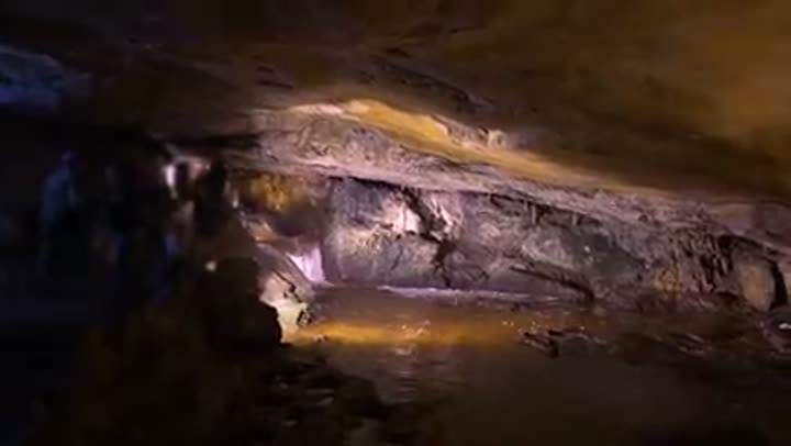
Arkansas's vast, largely unexplored subterranean world.
Arkansas boasts one of the largest concentrations of caves in the central United States, with over 2,000 documented caves, mostly in the limestone-rich Ozark region. These systems formed over millions of years as acidic groundwater dissolved carbonate rock. Blanchard Springs Caverns, a well-known example, features massive chambers and underground streams. Some passages host specialized, cave-adapted species that evolved in permanent darkness.
Ozark karst: a landscape of dissolving limestone.
Large parts of northern Arkansas sit on limestone that is slowly dissolving. Slightly acidic rainwater seeps into the bedrock, creating classic karst terrain. Across 22 Ozark counties, surveys document over 2,200 sinkholes and 800 springs. The Boone and Pitkin limestone formations host most of the state's massive cave systems. Surface streams often disappear underground, reemerging miles away through spring outlets.
Natural bridge: a hidden frontier crossing point.
In the 19th century, Ozark travelers routinely crossed a sandstone arch near present-day Rock Bridge without realizing its true nature. The formation blended so well that early wagon traffic treated it as ordinary ground. Only later did observers recognize the road passed over a natural rock bridge spanning a small gorge. The arch, roughly 50 feet long, formed through gradual erosion. It functioned as a frontier crossing before its geological significance was fully understood.
Pivot Rock: Eureka Springs' seemingly precarious balanced rock.
Near Eureka Springs stands Pivot Rock, a striking example of differential erosion. The formation appears almost top-heavy, with a broad upper mass balanced on a much narrower base. It formed as softer surrounding material weathered away, while more resistant cap rock remained. Though it looks precarious, the rock has remained stable for centuries. Pivot Rock became a tourist attraction in the late 19th century, a visually striking example of erosion's power.
Mount Magazine: Arkansas's highest, isolated summit.
Arkansas's highest point, Mount Magazine, rises to 2,753 feet above sea level. Unlike many high points within continuous mountain chains, Mount Magazine stands prominently above surrounding lowlands, with roughly 2,000 feet of local relief. Its isolation creates noticeably cooler conditions, often by 10 degrees Fahrenheit, and supports unusually high butterfly diversity, including the distinctive Diana Fritillary.
Elk herds successfully reintroduced to the Ozarks.
By the early 1900s, elk were eliminated from Arkansas. In 1981, wildlife officials reintroduced 112 Rocky Mountain elk into the Buffalo River region. The population successfully established, growing to an estimated 600 to 800 animals, primarily in Boxley Valley. Arkansas is now one of the few states outside the Rocky Mountain core with a free-ranging elk herd, a successful large mammal restoration effort.
Arkansas: a state dominated by extensive forests.
Arkansas is one of the most heavily forested states, with roughly 56 percent of its land area, about 19 million acres, covered by woodlands. These span diverse ecosystems, from pine-dominated Gulf Coastal Plain forests to oak-hickory stands in the Ozarks and Ouachitas, and cypress-tupelo swamps in the delta. This massive tree cover supports recovering black bear populations, abundant white-tailed deer, and a significant timber industry.
Under the Ozarks, Arkansas has a huge and still partially unexplored subterranean land.
Life's Unique Footprints and Ancient Echoes
Alligator gar: a prehistoric fish still thrives.
The alligator gar, found in parts of southern Arkansas, represents one of North America's oldest surviving fish lineages. Fossil evidence shows its ancestors existed over 100 million years ago. This "living fossil" retains primitive features like heavy ganoid scales and an elongated, tooth-filled snout. Arkansas waters have produced specimens over 200 pounds, offering a rare glimpse into a predatory fish body plan largely unchanged since the age of dinosaurs.
Ancient bald cypress: a 1,000-year-old living relic.
Within the White River National Wildlife Refuge stands a bald cypress estimated to be roughly 1,000 years old, making it one of Arkansas's oldest known trees. It's over 120 feet tall with a trunk circumference of about 44 feet. This giant began growing centuries before European contact. Protected refuges like White River preserve some of the last examples of these ancient bottomland forests, most of which were heavily logged.
Arkansas: a hotspot for unique endemic species.
Arkansas supports an unusually high number of endemic species, organisms found nowhere else on Earth, especially in its cave and karst environments. Biologists have documented well over 100 endemic invertebrates, fish, and amphibians. Many evolved in isolated underground systems, like the Ozark blind salamander. The state's varied geology created pockets of long-term ecological isolation, allowing unique species to diverge over time.
Thousands of dinosaur tracks discovered in a gypsum mine.
In 1983, workers in a gypsum mine near Nashville, Arkansas, uncovered thousands of dinosaur footprints preserved in ancient mudstone. Many tracks, some over 2 feet wide, were left by large sauropods roughly 100 million years ago. Parallel trackways suggest multiple animals moving together, providing rare insight into dinosaur behavior. Though mining destroyed much of the original surface, detailed casts preserve this significant discovery.
Arkansaurus fridayi: Arkansas's own official dinosaur.
Arkansas boasts its own official state dinosaur, Arkansaurus fridayi, designated in 2017. This fast, ostrich-like theropod lived about 113 million years ago. The species is known from fossil footbones discovered in 1972 near Lockesburg by farmer Joe Friday. The push to make it the state dinosaur was championed by Arkansas students, turning a quiet fossil discovery into an official piece of state identity.
Ivory-billed woodpecker: a controversial rediscovery claim.
For decades, the ivory-billed woodpecker was considered extinct, until Arkansas briefly reignited the debate. In 2004 and 2005, researchers reported sightings in the Big Woods region of eastern Arkansas, supported by video and audio evidence. This large black and white woodpecker had not been definitively confirmed since the mid-20th century. While follow-up searches failed to produce conclusive proof, Arkansas became the center of a major wildlife rediscovery claim.
Chinquapin snail's world: a tiny, isolated habitat.
One of Arkansas's rarest animals, the Magazine Mountain Chinquapin Snail, exists only on the upper slopes of Mount Magazine, generally above 2,200 feet in elevation. It survives in cool, moist rock stream habitats, jumbled boulder fields where water flows under the surface. These specialized microenvironments provide stable humidity and temperature conditions the species depends on. The snail is now considered threatened due to its extremely limited range.
Human Ingenuity and Landscape Transformations
Arkansas boasts unusual and distinctive place names.
Arkansas features some of the most distinctive place names in the US. "Toad Suck," a community along the Arkansas River, likely dates to the steamboat era when crews were said to "suck on the bottle till they swelled up like toads." The state map also includes "Smackover," "Flippin," "Booger Hollow," and "Success." Many are rooted in 19th-century local slang and frontier humor, reflecting informal naming traditions.

Mississippi River erased the 19th-century town of Napoleon.
The Mississippi River has repeatedly reshaped its course, in one case erasing an Arkansas town. Napoleon, once a major 19th-century riverport, began losing ground after Civil War-era channel changes. Accelerated erosion through the late 1800s gradually consumed the town site. By the 1870s, repeated flooding and bank collapse forced abandonment. Today, most of Napoleon sits under the Mississippi's shifting channel, a clear example of dynamic river systems rewriting human geography.
Little Rock's Big Dam Bridge: a record-holding pedestrian span.
Little Rock's Big Dam Bridge is a record holder, stretching 4,226 feet across the Arkansas River. It is North America's longest purpose-built pedestrian and bicycle bridge. Opened in 2006, it sits atop Murray Lock and Dam, linking over 40 miles of riverfront trails. What began as an infrastructure project became a statewide landmark, drawing tens of thousands of users annually for events like the Big Dam Bridge 100.
Rush: a zinc mining ghost town in a national river.
Hidden deep within the Buffalo National River Corridor lies Rush, Arkansas, a mining town that boomed and collapsed rapidly. In the early 1900s, Rush surged to nearly 5,000 residents as miners extracted zinc ore for World War I munitions. When wartime demand vanished and prices crashed, the population drained almost overnight. By mid-century, the town was largely abandoned. Weathered storefronts and mine structures are preserved today.
Arkansas's pronunciation officially set by state law.
Arkansas is one of the few US states whose pronunciation was formally settled by legislation. In 1881, the state legislature passed a resolution declaring the correct pronunciation as "Ar-kan-saw" with the final "s" silent. The name comes from the French rendering of the Quapaw people, and lawmakers wanted to preserve this historical pronunciation. This ended decades of debate, where outsiders often said "Our-Kansas."
Stuttgart: the epicenter of North American duck hunting.
Positioned along the Mississippi Flyway, Arkansas sits under one of North America's busiest migratory bird routes. Each winter, millions of ducks funnel into the state's flooded fields and wetlands. The city of Stuttgart has built an identity around this migration, hosting the World's Championship Duck Calling Contest since 1936. Arkansas consistently ranks among the top duck harvest states, closely tied to waterfowl migration.
Booger Hollow: Ozark humor in a two-story outhouse.
In the Ozark Hills, roadside culture blends folklore with practical jokes. One famous example is the two-story outhouse at Booger Hollow, a former tourist stop. Built as a deliberate sight gag, this stacked wooden privy became a regional curiosity, even featured in Ripley's Believe It or Not. Signs at the site leaned into the joke, reflecting the area's tradition of backwoods humor used to attract travelers.
Smackover oil boom rivaled Texas's early discoveries.
In the early 1920s, southern Arkansas experienced one of the fastest oil booms in the US. Towns like El Dorado and Smackover expanded almost overnight after major discoveries in the Smackover field. Smackover's population exploded from 100 residents to over 20,000 within a single year. By 1925, the field ranked among the world's most productive. The Arkansas Museum of Natural Resources preserves this period, documenting the rapid petroleum development.
From diamond-bearing volcanic pipes to subterranean rivers older than recorded history, Arkansas is a testament to the planet's ceaseless, often surprising, geological creativity. The stories etched into its rocks and carved by its waters reveal a state far more dynamic and complex than any textbook might suggest. This is the world as it truly is: a place of constant transformation, where every landscape holds plot twists and hidden narratives, waiting for curious minds to uncover them.


