Idaho, often dismissed as merely the "Potato State," conceals a geographic tapestry far more complex and dramatic than its agricultural fame suggests. This land, wedged between the Pacific Northwest and the American West, is a raw, untamed canvas of extremes. Here, you will find North America's deepest canyon, lava fields where astronauts once trained, and rivers that literally disappear into the earth. It is a state where the earth's fiery past and its glacial present collide, shaping a landscape of unparalleled wildness and wonder. Prepare to see the Gem State in a completely new light.
Volcanic Heartlands
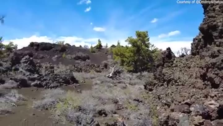
Craters of the Moon: Astronaut training ground.
Craters of the Moon National Monument and Preserve features vast lava flows and cinder cones that closely resemble the lunar surface. Apollo astronauts, including Neil Armstrong, trained here in the 1960s to prepare for moonwalks, studying the geology and practicing sample collection in this alien-like landscape.
Snake River Plain: Track of the Yellowstone Hotspot.
The arc-shaped Snake River Plain, stretching approximately 400 miles across southern Idaho, is a geological scar left by the Yellowstone Hotspot. As the North American tectonic plate moved southwest over the stationary hotspot, it created a chain of volcanic calderas, with Yellowstone National Park being its current manifestation.
Massive lava fields: Shaped by ancient eruptions.
Beyond Craters of the Moon, much of southern Idaho is covered by extensive lava fields, a testament to its violent volcanic past. These basaltic flows, some hundreds of feet thick, formed over millions of years, creating unique landforms like lava tubes, spatter cones, and vast, flat plains.
Boise's geothermal heating system: Largest in North America.
Boise boasts the largest geothermal heating system of any city in North America, tapping into a natural hot water aquifer beneath the city. This sustainable system provides heat to over 90 downtown buildings, including the State Capitol, demonstrating a practical use of Idaho's underground heat.
Perennial ice: Found in ancient lava tubes.
Deep within some of Idaho's ancient lava tubes, such as the Niter Ice Cave, ice persists year-round, even during the summer. These caves act as natural cold traps, where cold winter air sinks and becomes trapped, creating a unique microclimate that maintains **permanent ice formations**.
Volcanic rock dominates: Underneath much of Idaho.
Approximately two-thirds of Idaho's surface geology is composed of volcanic rock, primarily basalt from the Snake River Plain eruptions. This extensive volcanic activity has profoundly shaped the state's topography, soil composition, and water drainage patterns, making it a geological hotspot.
Magma chambers: Still active beneath the surface.
While Idaho is not currently experiencing large-scale eruptions, the Yellowstone Hotspot continues to generate seismic activity and maintain active magma chambers deep beneath the eastern Snake River Plain. This ongoing geological process causes frequent, though usually minor, earthquakes and contributes to the state's numerous hot springs and geothermal features.
Canyon Depths and Mountain Heights
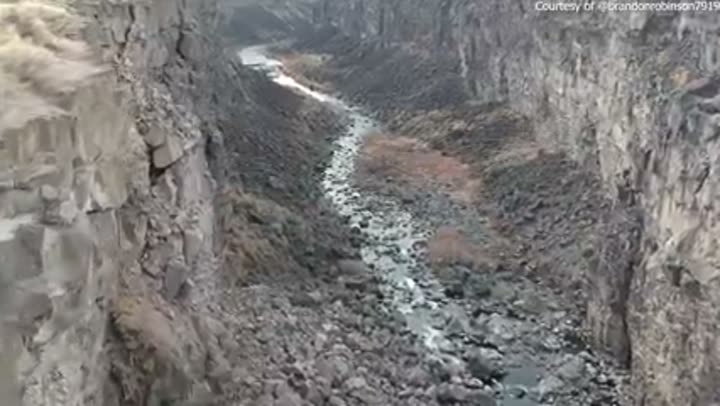
Hells Canyon: North America's deepest river gorge.
Hells Canyon, carved by the Snake River, plunges to an astonishing 7,993 feet, making it the deepest river gorge in North America. This immense chasm surpasses even the Grand Canyon by over 2,000 feet, offering breathtaking views and extreme elevation changes along its rugged walls.
Mount Borah: Idaho's towering highest peak.
Standing at 12,662 feet above sea level, Mount Borah is the highest point in Idaho, part of the Lost River Range. This challenging peak, often called "Smoky," is a popular destination for experienced mountaineers, offering panoramic views of Idaho's rugged, untamed wilderness.
Sawtooth Mountains: Rugged, glaciated alpine range.
The Sawtooth Mountains are an iconic range in central Idaho, known for their jagged, granite peaks that resemble sawteeth. This range boasts over 50 peaks exceeding 10,000 feet and features more than 300 alpine lakes, many carved by ancient glaciers, creating a stunning backdrop for outdoor activities.
Bitterroot Range: Forms part of Idaho's eastern border.
The formidable Bitterroot Range stretches for over 160 miles along the Idaho-Montana border, characterized by steep, heavily forested slopes and high, rugged peaks. This range is a significant barrier, historically challenging for westward expansion and today offering vast, remote wilderness.
Salmon River Mountains: Vast, remote wilderness.
The Salmon River Mountains cover a significant portion of central Idaho, creating one of the largest roadless areas in the lower 48 states. This expansive range is deeply incised by the Salmon River and its tributaries, forming a complex network of canyons and peaks that are largely inaccessible by road.
Galena Summit: Idaho's highest paved mountain pass.
Galena Summit, situated at an elevation of 8,701 feet, is the highest paved mountain pass in Idaho, located on State Highway 75. It connects the Wood River Valley with the Stanley Basin, offering spectacular views of the Sawtooth and Boulder Mountains, especially vibrant in autumn.
Lewiston: Idaho's lowest elevation city.
The city of Lewiston, located at the confluence of the Snake and Clearwater Rivers, sits at Idaho's lowest elevation, approximately 746 feet above sea level. Its low elevation provides a mild climate compared to the rest of the state and facilitates its role as an inland seaport.
Over 50 mountain ranges: Define Idaho's landscape.
Idaho is exceptionally mountainous, boasting more than 50 named mountain ranges that crisscross its terrain. These ranges, including the Sawtooth, Bitterroot, and Lost River ranges, define the state's rugged character and contribute to its diverse ecosystems and dramatic scenery.
Hells Canyon, carved by the Snake River, plunges to an astonishing 7,993 feet, making it the deepest river gorge in North America, surpassing even the Grand Canyon by over 2,000 feet.
Rivers That Vanish, Lakes That Hide
Shoshone Falls: Taller than Niagara, "Niagara of the West."
Shoshone Falls on the Snake River, near Twin Falls, plunges 212 feet, making it 45 feet taller than Niagara Falls. Known as the "Niagara of the West," it is one of the largest natural waterfalls in the United States and a powerful testament to the river's erosive force.
Lake Pend Oreille: Deepest lake, Navy submarine testing.
Lake Pend Oreille, in northern Idaho, is the deepest lake in the state and the fifth deepest in the United States, reaching a depth of 1,150 feet. Its immense depth and calm waters make it an ideal site for the U.S. Navy's Acoustic Research Detachment, which tests advanced submarine technology here.
Salmon River: "River of No Return," major whitewater.
The Salmon River, nicknamed the "River of No Return" for its once one-way journey, is one of the longest free-flowing rivers in the lower 48 states, stretching approximately 425 miles. It offers world-class whitewater rafting and flows through one of the most remote wilderness areas in the nation.
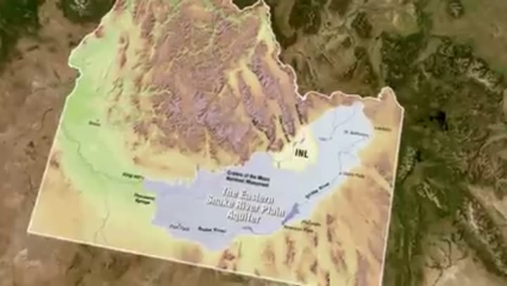
Big and Little Lost Rivers: Disappearing into the Snake River Plain.
The Big and Little Lost Rivers in central Idaho are prime examples of disappearing rivers, as their waters sink into the porous basalt of the Snake River Plain aquifer. Instead of flowing into the Snake River directly, their waters recharge the vast underground aquifer, making them a crucial part of Idaho's subterranean hydrology.
Bear Lake: Unique turquoise color, endemic species.
Bear Lake, straddling the Idaho-Utah border, is famous for its striking turquoise-blue waters, caused by suspended calcium carbonate crystals. This ancient lake is home to several endemic species of fish, including the Bear Lake sculpin and Bonneville cisco, found nowhere else on Earth.
Priest Lake: Pristine, clear waters, ancient cedars.
Priest Lake, nestled in the Selkirk Mountains of northern Idaho, is renowned for its exceptionally clear, deep blue waters and surrounding old-growth cedar forests. The lake reaches depths of over 300 feet and provides a pristine environment for recreation and wildlife, including rare woodland caribou.
Idaho's numerous hot springs: Most in the United States.
Idaho boasts over 300 natural hot springs, more than any other state in the continental United States. These geothermally heated pools are a direct result of the state's volcanic past and ongoing tectonic activity, offering therapeutic and recreational opportunities across its diverse landscapes.
Geological Wonders and Ancient Earth
Idaho Batholith: One of Earth's largest granite intrusions.
The Idaho Batholith is a massive body of igneous rock, primarily granite, that forms the core of central Idaho's mountain ranges. This immense geological feature, spanning approximately 15,400 square miles, represents one of the largest exposed batholiths on Earth, a testament to ancient tectonic forces.
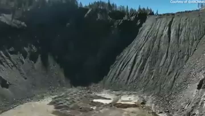
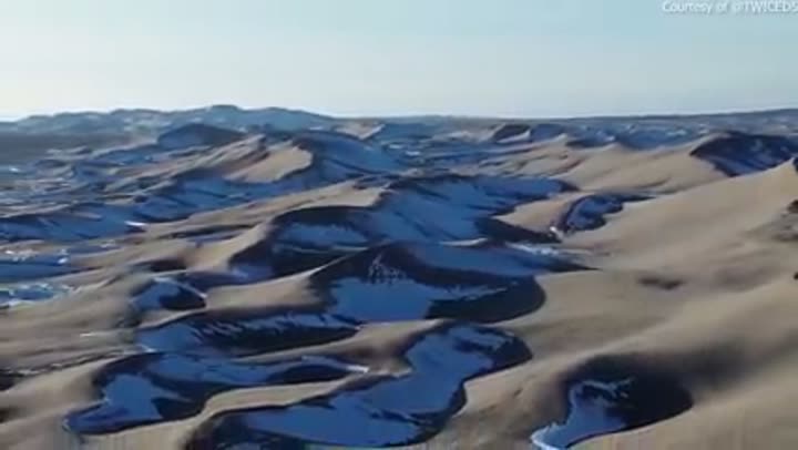
Bruneau Sand Dunes: North America's tallest single-structured dune.
Bruneau Dunes State Park is home to the tallest single-structured sand dune in North America, rising over 470 feet from the desert floor. Unlike most dunes that migrate, the Bruneau dunes remain relatively stationary due to conflicting wind patterns, creating a unique geological anomaly.
City of Rocks: Sculptural granite spires, emigrant landmark.
The City of Rocks National Reserve features extraordinary granite spires and monoliths sculpted by millions of years of erosion. This unique geological area served as a crucial landmark for emigrants on the California Trail, who often left their names in axle grease on the ancient rock faces.
Hagerman Fossil Beds: Rich in ancient horse fossils.
Hagerman Fossil Beds National Monument preserves one of the world's richest fossil deposits from the Pliocene epoch, approximately 3.5 million years ago. It is particularly famous for the Hagerman Horse, a zebra-like ancestor of modern horses, with over 200 individual specimens unearthed.
Star Garnet: Idaho's rare state gem.
Idaho is one of only two places in the world, the other being India, where star garnets are found in significant quantities. These unique gemstones exhibit a rare optical phenomenon called asterism, displaying a four-rayed or six-rayed star when viewed under direct light, making them highly prized.
Palouse region: Unique rolling loess hills.
The Palouse region, extending into western Idaho, is characterized by its distinctive rolling hills formed from deep deposits of windblown silt, or loess. These highly fertile soils, accumulated over thousands of years from glacial outwash, create a picturesque landscape ideal for dryland farming of wheat and lentils.
Missoula Floods: Left indelible marks across Idaho.
During the last Ice Age, catastrophic Missoula Floods, released from glacial Lake Missoula, dramatically reshaped parts of northern Idaho. These immense floods, occurring repeatedly over thousands of years, scoured canyons, deposited massive erratic boulders, and created unique geological features like the Channeled Scablands.
The Wild, Untamed Expanse
Frank Church Wilderness: Largest contiguous wilderness in lower 48.
The Frank Church River of No Return Wilderness, spanning 2.3 million acres, is the largest contiguous federally designated wilderness area in the lower 48 states. This vast expanse of rugged mountains and deep canyons is a testament to Idaho's commitment to untouched nature, remaining largely roadless and primitive.
Vast forest cover: Dominates nearly 40% of the state.
Forests cover approximately 39% of Idaho's land area, equating to over 20 million acres. These extensive forests, primarily coniferous, are vital for timber, wildlife habitat, and recreation, contributing significantly to the state's economy and its wild, natural character.
Wild and Scenic Rivers: Over 1,000 miles protected.
Idaho boasts over 1,000 miles of federally designated Wild and Scenic Rivers, more than any other state. These protected waterways, including portions of the Salmon, Snake, Selway, and Clearwater rivers, are preserved for their outstanding natural, cultural, and recreational values, ensuring their free-flowing status.
Over 100 wilderness areas: Protect Idaho's wild heart.
Idaho is home to numerous wilderness areas, beyond just the Frank Church, totaling over 4.7 million acres of federally protected land. These areas, managed by various agencies, ensure that vast tracts of the state remain untrammeled by human development, preserving their natural conditions.
Remote backcountry: Larger than many eastern states.
Idaho's vast, uninhabited backcountry, particularly in its central and northern regions, is larger than several eastern U.S. states combined. This expansive wilderness offers unparalleled opportunities for solitude and primitive recreation, making it a haven for those seeking to escape the pressures of modern life.
Abundant wildlife: Home to diverse ecosystems.
Idaho's diverse geography, from arid deserts to alpine tundra, supports an incredible array of wildlife. It is home to iconic species like grizzly bears, wolves, elk, moose, and bighorn sheep, reflecting its status as a critical habitat for North American megafauna.
Glacial lakes: Dot the high mountain country.
Idaho's high mountain ranges are dotted with thousands of pristine glacial lakes, formed by the erosive power of ancient ice sheets and glaciers. These clear, cold lakes, often found above 7,000 feet, are vital ecosystems and offer stunning scenery, especially in the Sawtooth and White Cloud Mountains.
The Frank Church River of No Return Wilderness, spanning 2.3 million acres, is the largest contiguous federally designated wilderness area in the lower 48 states, a testament to Idaho's commitment to untouched nature.
Borders, Lines, and Peculiar Shapes
Idaho's strange shape: A legacy of mining and politics.
Idaho's distinctive "panhandle" shape is largely a result of political maneuvering and the region's mining history in the late 19th century. Early statehood proposals aimed to combine the panhandle with Washington, but fierce lobbying by northern Idaho miners, who wanted to remain part of a larger, resource-rich territory, led to its unusual boundaries.
The Panhandle: Narrowest point, almost part of Washington.
The Idaho Panhandle is a slender strip of land, at its narrowest point only 45 miles wide, separating Washington from Montana. This geographic oddity was a point of contention during territorial days, with strong arguments for its annexation by Washington, ultimately unsuccessful due to local political influence.
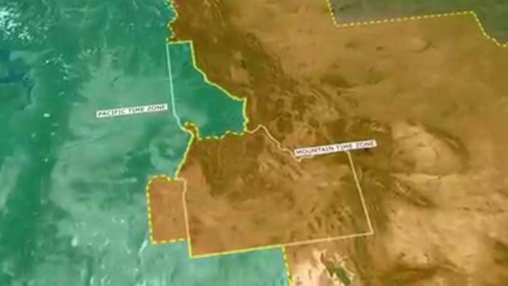
45th Parallel: Crosses Idaho, halfway to the North Pole.
The 45th parallel north latitude line, marking the halfway point between the equator and the North Pole, crosses through Idaho. This invisible line passes through several counties in the state, including Valley and Lemhi counties, signifying its position in the northern temperate zone.
Continental Divide: Forms much of Idaho's eastern border.
The Continental Divide of the Americas forms a significant portion of Idaho's eastern border with Montana and Wyoming. This geographical line dictates the flow of water, with rivers to the east eventually reaching the Atlantic Ocean and those to the west flowing towards the Pacific Ocean.
Longest state border: Shared with Montana.
Idaho shares its longest border with Montana, stretching approximately 467 miles. This extensive boundary traverses rugged mountain ranges, including the Bitterroot Mountains, and is largely defined by the Continental Divide, creating a formidable natural barrier.
Idaho's extensive borders: Shared with six states and Canada.
Idaho's geographical position means it shares land borders with six other U.S. states: Washington, Oregon, Nevada, Utah, Wyoming, and Montana. Additionally, its northernmost point borders the Canadian province of British Columbia, making it a truly central western state with diverse neighbors.
Lewiston's unique port: Farthest inland seaport on the West Coast.
Lewiston, Idaho, despite being hundreds of miles from the Pacific Ocean, functions as the farthest inland seaport on the U.S. West Coast. This is made possible by a system of locks and dams on the Snake and Columbia Rivers, allowing ocean-going barges to reach this landlocked state.
Subterranean Riches and Unique Stones
Silver Valley: Historic mining district, rich in metals.
The Silver Valley in northern Idaho is one of the most historically significant and productive mining districts in the world. It has yielded immense quantities of silver, lead, and zinc, earning Idaho the title of the "Gem State" and contributing significantly to the nation's mineral resources for over a century.
Idaho's silver production: Historically a national leader.
For much of the 20th century, Idaho was the leading silver-producing state in the United States, and at times, a global leader. Mines like the Sunshine Mine in the Silver Valley produced millions of ounces of silver, playing a vital role in the state's economic development and identity.
Snake River Aquifer: Vast underground water source.
The Snake River Plain Aquifer is one of the most productive aquifers in the United States, underlying a significant portion of southern Idaho. This immense underground reservoir stores billions of gallons of water, fed by rivers that disappear into the plain, and is a crucial source for irrigation and municipal water supply.
Fertile loess soils: Key to agricultural success.
Beyond the Palouse, many parts of Idaho benefit from rich, fertile soils derived from loess, fine windblown silt deposited during glacial periods. These deep, well-drained soils, particularly in the Snake River Plain, are ideal for cultivating crops like potatoes, sugar beets, and wheat, contributing to Idaho's agricultural prowess.
Active fault lines: Contribute to seismic activity.
Idaho lies within an active seismic zone, particularly along the eastern Snake River Plain and in its central mountain ranges. Numerous fault lines, including the Lost River Fault, are responsible for frequent, though mostly small, earthquakes, with the 1983 Borah Peak earthquake being a notable event.
Diverse mineral wealth: Beyond silver and gold.
While famous for silver, Idaho's mineral wealth extends to a wide array of resources, including phosphate, molybdenum, lead, zinc, and rare earth elements. The state's complex geological history, marked by volcanic activity and tectonic uplift, has created conditions for a rich diversity of extractable minerals.
Unique rock formations: Tell a complex geological story.
From the columnar basalt formations of Massacre Rocks to the granitic spires of the City of Rocks, Idaho's landscape is a showcase of unique rock formations. These geological wonders, sculpted by millennia of erosion, volcanic activity, and uplift, tell a compelling story of the Earth's dynamic past and present, offering a visual history of the planet.
So, the next time you picture Idaho, try to look beyond the vast potato fields and picture something far grander. This state is a living geological textbook, a place where ancient volcanoes still whisper beneath the surface, where rivers disappear into the earth, and where mountains stand as untamed as they were millennia ago. Idaho's geography is a constant reminder that the world is stranger, more dynamic, and infinitely more fascinating than any map or school textbook can fully convey.


